IMAGES TAKEN NEAR TO
Mill Road, WINCHELSEA, TN36 4HT
Introduction
This page details the photographs taken nearby to Mill Road, TN36 4HT by members of the Geograph project.
The Geograph project started in 2005 with the aim of publishing, organising and preserving representative images for every square kilometre of Great Britain, Ireland and the Isle of Man.

There are currently over 7.5m images from over14,400 individuals and you can help contribute to the project by visiting https://www.geograph.org.uk
Image Map
Images are licensed for reuse under creativecommons.org/licenses/by-sa/2.0
Notes
- Clicking on the map will re-center to the selected point.
- The higher the marker number, the further away the image location is from the centre of the postcode.
Image Listing (465 Images Found)
Images are licensed for reuse under creativecommons.org/licenses/by-sa/2.0
Image
Details
Distance
1
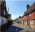
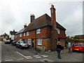
Mill Road, Winchelsea
A residential street linking Castle Street to Robert's Hill, the A259. The building on the left is The Old Post Office, marked as such on the 1898 and 1909 OS maps but had moved to High Street by the 1929 edition. On the right are Salutation Cottages, dating from the 15th century and once the Salutation Inn that is now three cottages.
Image: © Simon Carey
Taken: 24 May 2019
0.02 miles
2
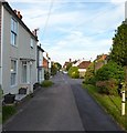
Mill Road, Winchelsea
Linking Roberts Hill, the A259, to Castle Street. On the original medieval plan of Winchelsea this was known as Second Street. Pound Cottage is the dwelling on the left.
Image: © Simon Carey
Taken: 1 Jun 2019
0.02 miles
3
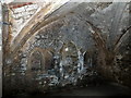
Medieval Cellar under Salutation Cottages, Winchelsea
Image: © PAUL FARMER
Taken: 2 Sep 2012
0.02 miles
4
Cellar Entrance, Salutation Cottages, Castle Street, Winchelsea
Open on this day due to a cellar tour in the town, about 15 people have just descended into the cellar which is owned by the National Trust. The cellars were built when the town was planned for the lucrative medieval wine trade with Gascony for which Winchelsea was the main port. In many cases the cellars were built before the houses and thus many are accessible from the street rather than inside the building. There are currently 33 still accessible with another 17 known about. In the case of Salutation Cottages which was once an inn its cellar would have been used for the storage of beer.
Image: © Simon Carey
Taken: 1 Jun 2019
0.02 miles
5
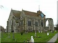
St. Thomas the Martyr Church. Winchelsea.
This church stands in Winchelsea, East Sussex.
The smallest town in England to have a Mayor.
Image: © Paul Russon
Taken: Unknown
0.02 miles
6
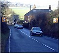
A259 at Winchelsea
The A259 used to go right through Winchelsea itself, a place reputed to be England's smallest town and perhaps even England's oldest new town, laid out in a grid pattern in the fourteenth century. Today the trunk road descends steeply to the stone 'Land Gate' - the slope shown here, and presents the driver with a dramatic hairpin-bend at the bottom. The valley in the background is that of the River Brede.
Image: © Adam Colton
Taken: Unknown
0.02 miles
7
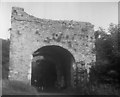
Winchelsea: Land Gate
Also referred to as Pipewell Gate
Image: © Dr Neil Clifton
Taken: 25 Aug 1955
0.02 miles
8
Salutation Cottages, Mill Road, Winchelsea
Image: © PAUL FARMER
Taken: 2 Sep 2012
0.02 miles
9
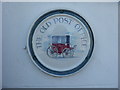
Plaque for The Old Post Office, Rye
One of the features of Rye for which it has long been famous is its potteries, especially the plaques which are found on many of the houses in Rye as well as in neighbouring places such as Winchelsea. Sadly many of the original potteries making these plaques seem to have closed. This example is in Castle Street in Winchelsea on the corner with Mill Road.
For more about the history of Winchelsea see https://www.visit1066country.com/destinations/winchelsea/history-of-winchelsea
Image: © Marathon
Taken: 18 Jun 2017
0.02 miles
10
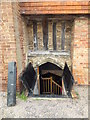
Entrance to Medieval Cellar under Salutation Cottages, Winchelsea
Image: © PAUL FARMER
Taken: 2 Sep 2012
0.02 miles