IMAGES TAKEN NEAR TO
Lower Waites Lane, HASTINGS, TN35 4DD
Introduction
This page details the photographs taken nearby to Lower Waites Lane, TN35 4DD by members of the Geograph project.
The Geograph project started in 2005 with the aim of publishing, organising and preserving representative images for every square kilometre of Great Britain, Ireland and the Isle of Man.

There are currently over 7.5m images from over14,400 individuals and you can help contribute to the project by visiting https://www.geograph.org.uk
Image Map
Images are licensed for reuse under creativecommons.org/licenses/by-sa/2.0
Notes
- Clicking on the map will re-center to the selected point.
- The higher the marker number, the further away the image location is from the centre of the postcode.
Image Listing (52 Images Found)
Images are licensed for reuse under creativecommons.org/licenses/by-sa/2.0
Image
Details
Distance
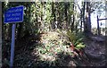
1
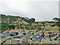
Fairlight Cove
Some of Fairlight's homes seem rather close to the sandstone cliffs. Taken from the National Trust land on the coastal path above Cliff End.
Image: © David M Clark
Taken: 20 May 2020
0.03 miles
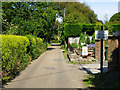
2
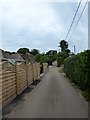
Briar Close, Fairlight Cove
A cul de sac off Lower Waites Lane that was laid out in the late 1920s and gradually built up over the follow decades.
Image: © Simon Carey
Taken: 4 Aug 2019
0.04 miles
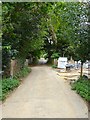
3
Lower Waites Lane, Fairlight Cove
Not yet touched by cliff erosion, but the next parallel road to the right, Sea Road, is only accessible from each end as the centre part has dropped into the sea.
Image: © Robin Webster
Taken: 5 Jul 2012
0.06 miles
4
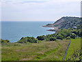
Houses close to the brink, Fairlight Cove
On Sea Road. Towards the right there are now no more permanent houses on the sea side of the road for some way because of cliff falls and the road itself is closed to vehicles. The near rocks are imported to act as a barrier to sea erosion of the cliff foot.
Image: © Robin Webster
Taken: 5 Jul 2012
0.09 miles
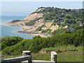
5
Fairlight Cove
Not really a cove, it was the fanciful name given to the cliff top settlement established here in the 1920s.
Image: © Robin Webster
Taken: 5 Jul 2012
0.09 miles
7
Primrose Hill, Fairlight Cove
A cul de sac off Lower Waites Lane that was laid out during the 1920s.
Image: © Simon Carey
Taken: 4 Aug 2019
0.11 miles
8
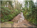
South end of Stream Lane, Fairlight Cove
This appears to have the status of a road, as it is signed 'Unfit for motor vehicles'. It looks as if a stream more or less coincides with it from time to time.
Image: © Robin Webster
Taken: 5 Jul 2012
0.11 miles
9
Cliff Way, Fairlight Cove
Residential road running south of Lower Waites Lane. The junction in the foreground is with the western part of Sea Road, once a through road but split into two through cliff erosion.
Image: © Simon Carey
Taken: 4 Aug 2019
0.12 miles