IMAGES TAKEN NEAR TO
Imperial Way, ASHFORD, TN23 5HT
Introduction
This page details the photographs taken nearby to Imperial Way, TN23 5HT by members of the Geograph project.
The Geograph project started in 2005 with the aim of publishing, organising and preserving representative images for every square kilometre of Great Britain, Ireland and the Isle of Man.

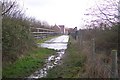
There are currently over 7.5m images from over14,400 individuals and you can help contribute to the project by visiting https://www.geograph.org.uk
Image Map
Images are licensed for reuse under creativecommons.org/licenses/by-sa/2.0
Notes
- Clicking on the map will re-center to the selected point.
- The higher the marker number, the further away the image location is from the centre of the postcode.
Image Listing (37 Images Found)
Images are licensed for reuse under creativecommons.org/licenses/by-sa/2.0
Image
Details
Distance
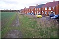
1
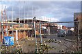
Redrow Houses near Singleton
Redrow is building more houses on the west of Singleton. The Paddocks is the sixth phase of a De Montfort Park development on Tithe Barn Lane.
See http://www.redrow.co.uk/assets/uploaded/documents/100_The%20Paddocks%20brochure.pdf for more details.
Image: © David Anstiss
Taken: 29 Nov 2009
0.13 miles
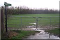
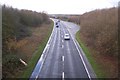
3
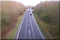
A28 Ashford Road towards Ashford
Seen from the bridleway bridge near Great Chart. The A28 leads from Tenterden and Bethersden to Ashford.
Image: © David Anstiss
Taken: 29 Nov 2009
0.15 miles
4
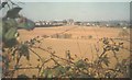
Distant view of Great Chart from Bucksford Lane in 1975
The arable land is now covered by housing. In the centre of the view is the tower of St Mary's church.
Image: © John Baker
Taken: Unknown
0.16 miles
5
Bridge over the A28 Ashford Road
This bridge is used by a bridleway heading from Great Chart to Mock Lane. It is also used by the Greensand Way (long distance path).
Image: © David Anstiss
Taken: 29 Nov 2009
0.17 miles
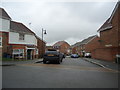
6
Greensand Way at the end of Hillcrest
The long distance path heads from a short road in Great Chart across several horse paddocks (on a bridleway) towards a footbridge over the A28.
Image: © David Anstiss
Taken: 29 Nov 2009
0.17 miles
7
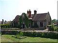
The Old School, Great Chart
Beautiful old building as it was in 2003. War memorial just to the left of the photo.
Image: © Dave Skinner
Taken: 30 May 2003
0.18 miles
8
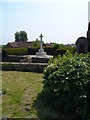
War Memorial, Great Chart
War Memorial as seen from the churchyard of St.Mary's Church
Image: © Dave Skinner
Taken: 30 May 2003
0.18 miles
9
A28 Ashford Road towards Bethersden
Seen from the bridleway bridge near Great Chart. The A28 leads from Ashford to Bethersden and Tenterden.
Image: © David Anstiss
Taken: 29 Nov 2009
0.18 miles
10
The Greensand Way heads towards Great Chart
The long distance path on a bridleway heads past a new housing estate (the De Montfort Park Development), towards a bridleway bridge over the A28 Ashford Road, from Mock Lane.
Image: © David Anstiss
Taken: 29 Nov 2009
0.19 miles