IMAGES TAKEN NEAR TO
Fletching, UCKFIELD, TN22 3PX
Introduction
This page details the photographs taken nearby to TN22 3PX by members of the Geograph project.
The Geograph project started in 2005 with the aim of publishing, organising and preserving representative images for every square kilometre of Great Britain, Ireland and the Isle of Man.

There are currently over 7.5m images from over14,400 individuals and you can help contribute to the project by visiting https://www.geograph.org.uk
Image Map
Images are licensed for reuse under creativecommons.org/licenses/by-sa/2.0
Notes
- Clicking on the map will re-center to the selected point.
- The higher the marker number, the further away the image location is from the centre of the postcode.
Image Listing (23 Images Found)
Images are licensed for reuse under creativecommons.org/licenses/by-sa/2.0
Image
Details
Distance
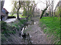
1
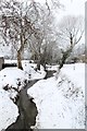
Fletching Mill
The (long disused) lock cut in winter at Fletching Mill
Image: © Martin Horsfall
Taken: 5 Feb 2012
0.00 miles
2
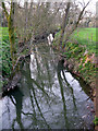
The River Ouse
At Fletching Mill Bridge.
Image: © Russel Wills
Taken: 5 Jun 2013
0.01 miles
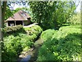
3
River Ouse at Fletching Mill Bridge
The summer growth of Himalayan Balsam has encroached from the banking, giving a false impression of its width.
Image: © Dave Spicer
Taken: 18 Sep 2011
0.01 miles
4
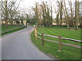
View along the road to Fletching near Fletching Mill
The road crosses the River Ouse at the bend in the road but the area is obviously liable to flooding as there is a raised walkway along the edge of the road, shown more clearly in other submissions.
Image: © Nick Smith
Taken: 18 Apr 2010
0.01 miles

6
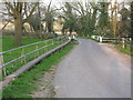
The road to Fletching at Fletching Mill
There is a raised concrete walkway along the edge of the road, presumably the road is prone to flooding by the River Ouse which runs underneath it where the white fencing can be seen.
Image: © Nick Smith
Taken: 18 Apr 2010
0.02 miles
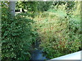
7
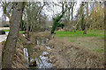
Fletching Mill lock cut, Ouse Navigation
Disused as a navigation for 150 years, the cut acts as a flood relief channel now, taking the major flow when required. Looking upstream, the lock is distantly visible, but now converted into a weir.
Image: © Robin Webster
Taken: 11 Mar 2010
0.02 miles
9
Fletching Mill Bridge
When it buckets down, this road can flood. There is a raised walkway so that pedestrians can keep their feet dry. The River Ouse flows out at Newhaven.
Image: © Nigel Freeman
Taken: 23 Jun 2005
0.02 miles
10
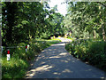
Fletching Mill lock cut
See Image for photo taken 1 month earlier and a description.
Image: © Nick Smith
Taken: 18 Apr 2010
0.03 miles