IMAGES TAKEN NEAR TO
Burwash, ETCHINGHAM, TN19 7DL
Introduction
This page details the photographs taken nearby to TN19 7DL by members of the Geograph project.
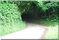
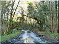
The Geograph project started in 2005 with the aim of publishing, organising and preserving representative images for every square kilometre of Great Britain, Ireland and the Isle of Man.

There are currently over 7.5m images from over14,400 individuals and you can help contribute to the project by visiting https://www.geograph.org.uk
Image Map
Images are licensed for reuse under creativecommons.org/licenses/by-sa/2.0
Notes
- Clicking on the map will re-center to the selected point.
- The higher the marker number, the further away the image location is from the centre of the postcode.
Image Listing (16 Images Found)
Images are licensed for reuse under creativecommons.org/licenses/by-sa/2.0
Image
Details
Distance
2
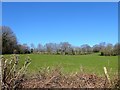
Hollow Field
The name of the field according to Brightling's 1838 tithe map that is located to the north of the public bridleway.
Image: © Simon Carey
Taken: 22 Mar 2020
0.12 miles
3
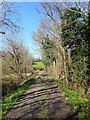
Brightling 5b Bridleway
Here crossing an old embankment next to a pond formed by the extraction of clay for a nearby former brickworks, see Image The bridleway links Brickyard Lane to Perryman's Farm.
Image: © Simon Carey
Taken: 22 Mar 2020
0.14 miles
4
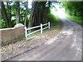
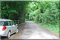
Bridge over the River Rother
This lane has just crossed the headwaters of the infant River Rother and is going uphill on its way to Fontridge Lane. The edge of Little Hoaths Wood is to the left and the edge of Great Hoaths Wood is to the right.
The source of the River Rother is not far from here and it eventually flows into the English Channel at Rye Bay. See https://en.wikipedia.org/wiki/River_Rother,_East_Sussex for more information on the Rother.
Image: © Marathon
Taken: 15 Aug 2015
0.19 miles
5
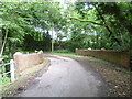
Bridge over the infant River Rother
This lane is crossing the headwaters of the infant River Rother and is going uphill on its way to Fontridge Lane. The edge of Little Hoaths Wood is to the left and the edge of Great Hoaths Wood is to the right.
The source of the River Rother is not far from here and it eventually flows into the English Channel at Rye Bay. See https://en.wikipedia.org/wiki/River_Rother,_East_Sussex for more information on the Rother.
Image: © Marathon
Taken: 15 Aug 2015
0.20 miles
6
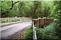
Bridge over Unnamed Stream, Great Wood
Image: © Julian P Guffogg
Taken: 11 Jun 2011
0.20 miles
7
Bridge over stream near Brown's Oak Farm
Both the lane and the stream have no mapped name, but the Environment Agency call the stream the 'Socknersh Stream'. The stream joins the Rother near Robertsbridge.
Image: © Robin Webster
Taken: 7 Dec 2012
0.20 miles
8
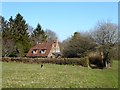
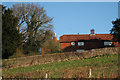
Brickyard Cottage
A reminder of the former brickworks that once operated here. The works but not the cottage are marked on Brightling's 1838 tithe map with the cottage appearing on the 1874 OS map. The works still appeared on a 1930 edition but not thereafter.
Image: © Simon Carey
Taken: 22 Mar 2020
0.20 miles