IMAGES TAKEN NEAR TO
Old Rectory Fields, TELFORD, TF6 6PL
Introduction
This page details the photographs taken nearby to Old Rectory Fields, TF6 6PL by members of the Geograph project.
The Geograph project started in 2005 with the aim of publishing, organising and preserving representative images for every square kilometre of Great Britain, Ireland and the Isle of Man.

There are currently over 7.5m images from over14,400 individuals and you can help contribute to the project by visiting https://www.geograph.org.uk
Image Map
Images are licensed for reuse under creativecommons.org/licenses/by-sa/2.0
Notes
- Clicking on the map will re-center to the selected point.
- The higher the marker number, the further away the image location is from the centre of the postcode.
Image Listing (22 Images Found)
Images are licensed for reuse under creativecommons.org/licenses/by-sa/2.0
Image
Details
Distance
1
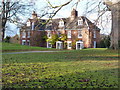
Waters Upton Hall
This is a Grade II* listed building, originally a 16th century timber-framed house, subsequently encased in brick in the 18th century.
http://www.britishlistedbuildings.co.uk/en-362409-the-hall-waters-upton
Image: © Richard Law
Taken: 3 Dec 2011
0.06 miles
2
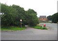
River Lane, Waters Upton near Telford, Shropshire
River Lane leads to the main part of the village of Waters Upton. It is seen here at its junction with the A442 road. On the right is part of the car park of the Swan public house.
Image: © P L Chadwick
Taken: 25 Aug 2013
0.08 miles
3
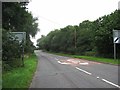
A442 road at Waters Upton near Telford, Shropshire
In this direction the road is heading towards the village of Hodnet, where it meets the A53 road just outside the village. In the other direction it goes to Droitwich Spa in Worcestershire, via Telford, Bridgnorth and Kidderminster.
Image: © P L Chadwick
Taken: 25 Aug 2013
0.08 miles
4
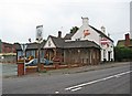
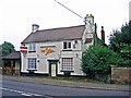
The Swan (2), Waters Upton near Telford, Shropshire
Currently closed and for sale, this public house is or was owned by the well-known Punch Taverns.
Image
Image
Image: © P L Chadwick
Taken: 25 Aug 2013
0.08 miles
5
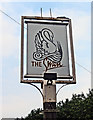
The Swan (3) - sign, Waters Upton near Telford, Shropshire
In times past when many people couldn't read, inn and pub signs needed to contain a subject that was easy to illustrate and to recognise. The swan or often the white swan became a popular name as a result. It was also associated with innocence and with royalty.
Image
Image
Image: © P L Chadwick
Taken: 25 Aug 2013
0.09 miles
6
The garden wall of Waters Upton Hall
The sandstone wall on the south side of the garden of Image was built in the 19th century, is presumed to be made of re-used blocks, and was Grade II listed https://britishlistedbuildings.co.uk/101352006-garden-boundary-wall-south-of-the-hall-waters-upton#.XBGCtdSLTGg in 1983.
Image: © Richard Law
Taken: 17 Nov 2018
0.09 miles
7
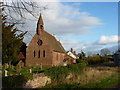
St Michael's Parish church, Waters Upton
A Grade II listed building, dated from 1865, when it was built by GE Street.
http://www.britishlistedbuildings.co.uk/en-362405-church-of-st-michael-waters-upton
Image: © Richard Law
Taken: 3 Dec 2011
0.09 miles
8
The Swan (1), Waters Upton near Telford, Shropshire
Another currently closed public house on the A442 road. This has a sign saying it is for sale. Early in 2012 there had been a planning application for residential units on the car park and garden of the pub, which the Parish Council strongly objected to. The outline application was refused in September 2012. The pub had previously closed in 2007, then reopened, but appears to have closed again by the time of the planning application.
Image
Image
Image: © P L Chadwick
Taken: 25 Aug 2013
0.09 miles
9
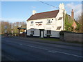
The Swan Inn, Waters Upton
Still running as a pub in 2011 (unlike the nearby Lion), it sits on the main A442 towards Hodnet.
Update as at October 2016 - this business suffered a significant fire to the premises in 2015, and has been closed ever since.
Image: © Richard Law
Taken: 3 Dec 2011
0.09 miles
10
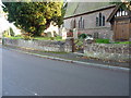
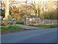
Churchyard boundary wall, Waters Upton
This sandstone retaining wall, including the squat gatepiers, for the raised churchyard was probably built in the late 18th or early 19th century, and was Grade II listed https://britishlistedbuildings.co.uk/101352004-churchyard-boundary-wall-north-of-church-of-st-michael-waters-upton#.XBGDxdSLTGg in 1983.
Image: © Richard Law
Taken: 17 Nov 2018
0.09 miles