IMAGES TAKEN NEAR TO
Crugetone Way, TELFORD, TF6 6FB
Introduction
This page details the photographs taken nearby to Crugetone Way, TF6 6FB by members of the Geograph project.
The Geograph project started in 2005 with the aim of publishing, organising and preserving representative images for every square kilometre of Great Britain, Ireland and the Isle of Man.

There are currently over 7.5m images from over14,400 individuals and you can help contribute to the project by visiting https://www.geograph.org.uk
Image Map
Images are licensed for reuse under creativecommons.org/licenses/by-sa/2.0
Notes
- Clicking on the map will re-center to the selected point.
- The higher the marker number, the further away the image location is from the centre of the postcode.
Image Listing (19 Images Found)
Images are licensed for reuse under creativecommons.org/licenses/by-sa/2.0
Image
Details
Distance
1

This was a railway line before dear Dr Beeching
Image: © Row17
Taken: 31 Oct 2008
0.08 miles
2
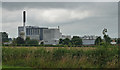
Creamery near Crudgington
Somehow Crudgington sounds like an appropriate location for a creamery.
This plant produces butter and similar spreads for retail use, as well as conducting related research.
Image: © Stephen Richards
Taken: Unknown
0.08 miles
3
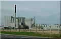
Creamery
Dairycrest creamery at Crudgington near Telford.
Image: © Andy and Hilary
Taken: 17 Apr 2005
0.08 miles
4
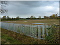
All gone now
Nothing remains now of the former Crudgington Creamery, seen in 2005 as Image, and whose demolition has been so poignantly recorded in some of these pictures:-
Image
Image
Image
Image: © Richard Law
Taken: 5 Nov 2017
0.10 miles
5
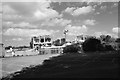
Another view of Crudgington creamery
The milk silos - six of them - filled the gap between the remains of the process room in the centre of the shot. In the foreground is the staff car park, and between that and the process room was the intake bay where the milk tankers used to unload, and the weighbridge lab.
Image: © John Winder
Taken: 27 Sep 2015
0.11 miles
6
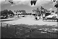
Last remnants of Crudgington creamery
This picture brought back some memories for me, since I worked here (my first proper job!) for nearly four years in the mid to late 1990s. I started in the quality control lab, then moved down to the milk processing room where I worked in a crew of three operating milk separators and pasteurisers and all sorts of other machines.
This shot - taken blind by holding my Pentax K1000 up above my head to point over the fence, since the security guard wouldn't let me on the site - shows the last remnants of the entrance hall (behind the arm of the digger) and the process room and intake bay (behind the second digger in the background). The pile of debris to the left of the shot marks the position of the weighbridge laboratory. In the gap between the building remains were once a number of large silos used for storing raw milk and visible for miles around. It made me quite sad to see the place like this, but I'm glad I visited before it had all disappeared.
Image: © John Winder
Taken: 27 Sep 2015
0.12 miles
7
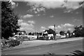
Security hut at Dairy Crest, Crudgington
This was the only part of the site still being used for its original purpose when I visited! The last stages of demolition were just being completed, prior to the site being redeveloped as housing. Once upon a time, the Dairy Crest plant was a landmark for miles around: having worked here, and commuted by bicycle from Wolverhampton, 23 miles away, I was more familiar with the view of the place from across the fields than most, and it came as a bit of a shock to drive towards the site and not be able to see it. In the background was once the canteen and office block and the "Special Products" division, where things like brandy butter were made at Christmas time.
Image: © John Winder
Taken: 27 Sep 2015
0.13 miles
8
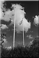
Dairy Crest flag at Crudgington
The Dairy Crest flag - probably the very same one which flew when I worked here nearly twenty years ago - still flies from the flagpole which stands in front of where the canteen and offices used to be. It's looking a bit the worse for wear here! Taken with a Pentax K1000 with a red filter on the lens, hence the dark sky.
Image: © John Winder
Taken: 27 Sep 2015
0.13 miles
9
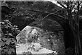
Old railway bridge at Crudgington
Crudgington once had a railway station, on the Wellington & Drayton Railway which was opened in 1867 and operated under the auspices of the Great Western Railway. Traffic was never heavy, although the line was used for diversionary traffic right up until closure, especially during electrification work on the London - Crewe line. The establishment of a number of RAF bases in the area during WWII gave a boost to traffic levels and a good deal of freight traffic also used the line, but all to no avail as passenger traffic ceased in 1963, followed by freight in 1967. The track was lifted during 1970. The station master's house and this bridge are all that survive at Crudgington, along with some overgrown steps to where the platform once was and some bits of fencing.
Image: © John Winder
Taken: 27 Sep 2015
0.16 miles
10
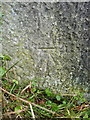
OS benchmark - Crudgington, gatepost east side of A442
An OS cutmark on a stone gatepost just to the SE of the Crudgington crossroads. It was levelled at 58.228m above Ordnance Datum Newlyn in 1958.
Image: © Richard Law
Taken: 5 Nov 2017
0.18 miles