IMAGES TAKEN NEAR TO
Boatwell Meadow, TELFORD, TF4 3QY
Introduction
This page details the photographs taken nearby to Boatwell Meadow, TF4 3QY by members of the Geograph project.
The Geograph project started in 2005 with the aim of publishing, organising and preserving representative images for every square kilometre of Great Britain, Ireland and the Isle of Man.

There are currently over 7.5m images from over14,400 individuals and you can help contribute to the project by visiting https://www.geograph.org.uk
Image Map (Loading...)


Getting Data...Please wait
Leaflet Map data © OpenStreetMap
Images are licensed for reuse under creativecommons.org/licenses/by-sa/2.0
Notes
- Clicking on the map will re-center to the selected point.
- The higher the marker number, the further away the image location is from the centre of the postcode.
Image Listing (12 Images Found)
Images are licensed for reuse under creativecommons.org/licenses/by-sa/2.0
Image
Details
Distance
1
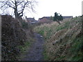
Little Dawley Rivet Benchmark
The Ordnance Survey Rivet Benchmark set into a stone off Holly Road, Little Dawley, Telford. The stone sits off a footpath that links Holly Road to Gravel Leasows.
Image: © Anthony Rowley
Taken: 19 Nov 2022
0.05 miles
2
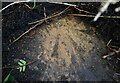
Rails no longer in use
This is all that's left of the railwayline through Doseley.
Image: © Row17
Taken: 18 Mar 2008
0.12 miles
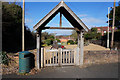
5
War Memorial at Dawley Parva
On Holly Road, Little Dawley. http://www.geograph.org.uk/photo/4897647
Image: © Ian S
Taken: 31 Mar 2016
0.17 miles
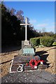
6
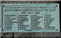
War Memorial at Dawley Parva
On Holly Road, Little Dawley. http://www.geograph.org.uk/photo/4897641
Image: © Ian S
Taken: 31 Mar 2016
0.17 miles
7

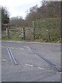
Little Dawley Canal Bridge
This canal bridge was restored in 1994. The canal flowed through it, whilst a tramway carrying coal went over the top.
Image: © Roger Dean
Taken: 23 Oct 2005
0.19 miles
8
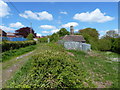
Outbuilding of Stocking Farm
Stocking Farm was one of three farms in the Lightmoor area, left undeveloped by Telford until 2009 or 2010. The main farm buildings are now in the process of conversion and improvement (2010), but I don't rate the chances of this small cottage lasting too long.
Update August 2020. It turns out I was completely wrong at that front, as the tiny building is in reality a rare survival of a late 18th century squatter's cottage, dated to 1797, and built by a local miner called Robert Bayley, earning himself a 6d fine for "an encroachment upon the Lord's waste". It was Grade II listed https://britishlistedbuildings.co.uk/101030945-squatters-cottage-at-national-grid-reference-sj6764105978-dawley-hamlets#.X0KTkMhKjcs & https://historicengland.org.uk/listing/the-list/list-entry/1030945 in 1992, and has recently been restored from a rather dilapidated condition to become a community education facility, hosting courses and small displays by the local school and Shropshire Wildlife Trust.
Image: © Richard Law
Taken: 9 May 2010
0.19 miles
9

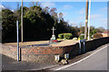
Wesleyan Chapel on Holly Road, Little Dawley
Built in 1837.
Image: © Ian S
Taken: 31 Mar 2016
0.19 miles