IMAGES TAKEN NEAR TO
St. Pauls Drive, TELFORD, TF1 3GD
Introduction
This page details the photographs taken nearby to St. Pauls Drive, TF1 3GD by members of the Geograph project.
The Geograph project started in 2005 with the aim of publishing, organising and preserving representative images for every square kilometre of Great Britain, Ireland and the Isle of Man.

There are currently over 7.5m images from over14,400 individuals and you can help contribute to the project by visiting https://www.geograph.org.uk
Image Map
Images are licensed for reuse under creativecommons.org/licenses/by-sa/2.0
Notes
- Clicking on the map will re-center to the selected point.
- The higher the marker number, the further away the image location is from the centre of the postcode.
Image Listing (16 Images Found)
Images are licensed for reuse under creativecommons.org/licenses/by-sa/2.0
Image
Details
Distance
1
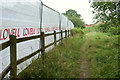
Path, Wellington
Linking the A4223 Whitchurch Drive to St Paul's Drive, where the houses ahead are. It was getting rather dark, and it turned out to be a little awkward, at least at the main road (behind the camera), as a building site (left, where 54 new houses are being built) was sort of in the way.
Image: © Derek Harper
Taken: 26 Jul 2019
0.02 miles
2
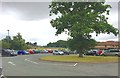
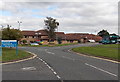
Princess Royal Hospital, Telford: car park
Image: © Jonathan Hutchins
Taken: 22 Jul 2015
0.10 miles
3
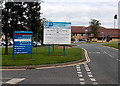
Welcome to the Princess Royal Hospital in Wellington
The welcome sign is alongside the entrance road from the Apley Roundabout.
Image: © Jaggery
Taken: 10 Oct 2013
0.17 miles
4
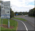
Locations near Wellington Shropshire
The sign is alongside Apley Avenue on the approach to Apley Roundabout.
Why are no distances shown?
Image: © Jaggery
Taken: 10 Oct 2013
0.18 miles
5
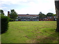
The Blessed Robert Johnson college ('the BRJ')
A long-established Catholic college in Wellington, named after a Shropshire-born priest of the 16th Century. The school is currently (mid 2012) in the throes of considering a move to new premises in the Priorslee area, under the previous (Labour) Government's Building Schools for the Future project.
Image: © Richard Law
Taken: 4 Aug 2012
0.18 miles
6
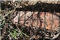
Princess Royal Hospital Culvert Benchmark
The Ordnance Survey Rivet Benchmark set into the drainage culvert adjacent to the Princess Royal Hospital in Telford. It is 3-metres from the footpath. Grid Reference SJ 65516 12674. The recorded AODN is 85.74-metres. It was levelled and verified by the OS in 1984.
Image: © Anthony Rowley
Taken: 18 Mar 2022
0.19 miles
8
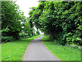
The Silkin Way
The Silkin Way, long distance footpath that runs from Bratton to Ironbridge, looking North-west as it curves around Apley Castle Woods.
Image: © Gordon Cragg
Taken: 25 May 2009
0.20 miles
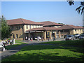
9
South side of the Princess Royal Hospital in Wellington
Viewed from the entrance road from the Apley Roundabout. On the right, an Arriva bus is at a bus stop.
Image: © Jaggery
Taken: 10 Oct 2013
0.20 miles
10
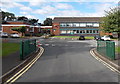
South side of Blessed Robert Johnson Catholic College, Wellington
Viewed from the entrance road from Apley Avenue. A specialist humanities college, this is the only Roman Catholic secondary comprehensive in Shropshire.
A Shropshire native, Robert Johnson was a Catholic priest and martyr during the reign of Queen Elizabeth I. He was beatified in 1889, the first step to canonisation.
Image: © Jaggery
Taken: 10 Oct 2013
0.21 miles