IMAGES TAKEN NEAR TO
Tanglewood Close, SHIFNAL, TF11 9AT
Introduction
This page details the photographs taken nearby to Tanglewood Close, TF11 9AT by members of the Geograph project.
The Geograph project started in 2005 with the aim of publishing, organising and preserving representative images for every square kilometre of Great Britain, Ireland and the Isle of Man.

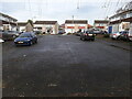
There are currently over 7.5m images from over14,400 individuals and you can help contribute to the project by visiting https://www.geograph.org.uk
Image Map (Loading...)


Getting Data...Please wait
Leaflet Map data © OpenStreetMap
Images are licensed for reuse under creativecommons.org/licenses/by-sa/2.0
Notes
- Clicking on the map will re-center to the selected point.
- The higher the marker number, the further away the image location is from the centre of the postcode.
Image Listing (115 Images Found)
Images are licensed for reuse under creativecommons.org/licenses/by-sa/2.0
Image
Details
Distance
1
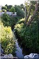
Wesley Brook leaves Shifnal
This is taken from the same bridge as Image,but looking downstream, as the brook emerges from the town and sets off to wind through countryside on its way to the river Worfe.
Image: © Mike White
Taken: 14 Jun 2009
0.04 miles
2
Corner of Brimstree Drive and Applebrook
The other end of Brimstree Drive near Park Lane was here when we moved to the area in the late 1960s, although it would have been quite recently built at that time. This end, with Applebrook was developed in the late 1970s, possibly early '80s.
Image: © Richard Law
Taken: 12 Dec 2020
0.04 miles
3
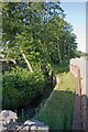
Wesley Brook
The brook emerges from the private domain again to pass under a substantial stone bridge bearing a footpath that connects Tanglewood Close on the left bank with Stafford Avenue on the right. We're looking upstream here, so left is right and vice versa, OK?
Image: © Mike White
Taken: 14 Jun 2009
0.04 miles
4
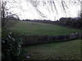
Field to the west of Brimstree Drive
A small patch of a private garden, and an open field beyond, which is pretty much in the valley of the Wesley Brook.
Image: © Richard Law
Taken: 26 Dec 2020
0.05 miles
5
Cul de sac of housing off Brimstree Drive
Image: © Richard Law
Taken: 26 Dec 2020
0.06 miles
6
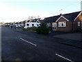
Bungalows on the south side of Stafford Avenue
These bungalows all back onto the Wesley Brook, and many have needed to be shored up or even underpinned over the years as the valley consists of rather damp ground in places.
Image: © Richard Law
Taken: 12 Dec 2020
0.07 miles
7
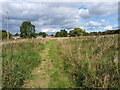
An informal path in the field
This path appears to go nowhere very much at all. Behind me, it fizzled out in long, more or less impenetrable grass/nettles/burdock/brambles etc. Ahead of me, it led to the rear fences of the houses in the distance, but didn't seem to serve any real purpose other than to provide someone's strimmer with a bit of exercise. Rather odd.
Image: © Richard Law
Taken: 16 Sep 2021
0.08 miles
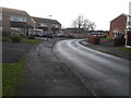
8
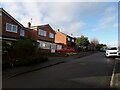
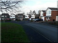
Houses on Stafford Avenue
Built in the early 1960s, these houses form part of an estate that was built on land once owned by the Lord Stafford.
Image: © Richard Law
Taken: 15 Dec 2020
0.09 miles
9
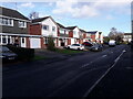
Houses on Applebrook
Applebrook was built in the late '70s or early '80s, some while after the original development of the nearby Image
Image: © Richard Law
Taken: 15 Dec 2020
0.10 miles
10
Houses on the corner of Brimstree Drive
Image: © Richard Law
Taken: 26 Dec 2020
0.10 miles