IMAGES TAKEN NEAR TO
Audley Avenue Enterprise Park, NEWPORT, TF10 7DW
Introduction
This page details the photographs taken nearby to Audley Avenue Enterprise Park, TF10 7DW by members of the Geograph project.
The Geograph project started in 2005 with the aim of publishing, organising and preserving representative images for every square kilometre of Great Britain, Ireland and the Isle of Man.

There are currently over 7.5m images from over14,400 individuals and you can help contribute to the project by visiting https://www.geograph.org.uk
Image Map
Images are licensed for reuse under creativecommons.org/licenses/by-sa/2.0
Notes
- Clicking on the map will re-center to the selected point.
- The higher the marker number, the further away the image location is from the centre of the postcode.
Image Listing (7 Images Found)
Images are licensed for reuse under creativecommons.org/licenses/by-sa/2.0
Image
Details
Distance
1
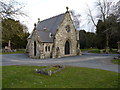
Chapel of Remembrance in the Newport cemetery
A small, stone-built chapel in the centre of the town's cemetery.
Image: © Richard Law
Taken: 4 Apr 2013
0.08 miles
2
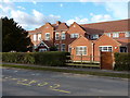
Audley Court - the eastern end
Formerly a care home for the elderly and before that the infirmary of the Newport Poor Law Union Workhouse, Audley Court now serves as a residential facility for ex-service personnel, and is operated by the Combat Stress charity.
http://www.combatstress.org.uk/veterans/contact-us/audley-court,-shropshire/
Image: © Richard Law
Taken: 4 Apr 2013
0.15 miles
3
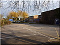
The Burton Borough school
Built in the mid 1950s, Burton Borough was for many years the town's Secondary Modern. It now has Specialist Arts College status, obtained in 2004, and caters for just over 1000 students.
http://www.burtonborough.wrekin.sch.uk/index.html
Image: © Richard Law
Taken: 4 Apr 2013
0.17 miles
4
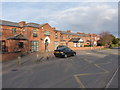
Audley House - the western end
This end of the buildings of Audley Court was the original Newport Poor Law Union Workhouse http://www.workhouses.org.uk/NewportSalop/ which was built in the mid 1850s, but is now converted to residential use. At the eastern end, the original workhouse was extended in 1908 with a 29-bed infirmary, which is partly visible in Image, and which is now part of residential facility operated by the Combat Stress charity for ex-forces personnel.
Image: © Richard Law
Taken: 4 Apr 2013
0.18 miles
6
A41 route confirmatory sign north of the A518 roundabout
Stafford is shown in brackets as it reached by another route: in this case the A518 which route runs in tandem with the A41 for about a half-mile.
Image: © Peter Whatley
Taken: 29 Nov 2011
0.24 miles