IMAGES TAKEN NEAR TO
Tower Knowe, HAWICK, TD9 9DQ
Introduction
This page details the photographs taken nearby to Tower Knowe, TD9 9DQ by members of the Geograph project.
The Geograph project started in 2005 with the aim of publishing, organising and preserving representative images for every square kilometre of Great Britain, Ireland and the Isle of Man.

There are currently over 7.5m images from over14,400 individuals and you can help contribute to the project by visiting https://www.geograph.org.uk
Image Map
Images are licensed for reuse under creativecommons.org/licenses/by-sa/2.0
Notes
- Clicking on the map will re-center to the selected point.
- The higher the marker number, the further away the image location is from the centre of the postcode.
Image Listing (284 Images Found)
Images are licensed for reuse under creativecommons.org/licenses/by-sa/2.0
Image
Details
Distance
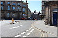
1
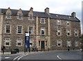
Heart of Hawick
This old mill converted, among other things, into a textile Museum. For more info I suggest http://www.scotborders.gov.uk/council/specialinterest/heartofhawick/
Image: © David Clark
Taken: 16 Apr 2011
0.00 miles
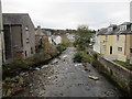
2
The Slitrig Water
Heading for its confluence with the River Teviot having just emerged from below the Bean Scene in Hawick.
Image: © James Denham
Taken: 27 May 2014
0.00 miles
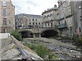
3
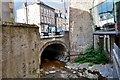
The Slitrig Water, Hawick
The Slitrig Water flowing beneath the High Street just before the confluence with the Teviot, seen from Silver Street.
Image: © Jim Barton
Taken: 8 Aug 2016
0.00 miles
4
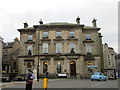
Border Brides
Former Commercial Bank of Scotland. Designed by Alexander Pirnie (according to The Buildings of Scotland - Borders) or David Rhind (listed buildings https://www.britishlistedbuildings.co.uk/200378919-hawick-4-tower-knowe-hawick#.WhM-czdpHVI) 1852. However Dictionary of Scottish Architects suggests James Harkness was the architect but that the other two were involved as mason (Pirnie) and advisor on security (Rhind) http://www.scottisharchitects.org.uk/architect_full.php?id=206556
Image: © Jonathan Thacker
Taken: 3 Nov 2017
0.00 miles
6
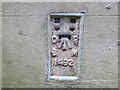
Ordnance Survey Flush Bracket 1492
This can be found on the wall of a former Bank building in Hawick.
For more detail see : http://www.bench-marks.org.uk/bm970
Image: © Peter Wood
Taken: 13 Oct 2015
0.01 miles
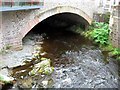
7
Slitrig Water seen from Drumlanrig Bridge
Looking towards the confluence with the River Teviot.
Image: © Jonathan Thacker
Taken: 3 Nov 2017
0.01 miles
8
The Slitrig Water, Hawick
The Slitrig Water is channelled through the town and meets the River Teviot close by, out of shot to the right.
Image: © Jim Barton
Taken: 2 Oct 2020
0.01 miles
9
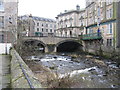
Drumlanrig Bridge, Hawick
Drumlanrig Bridge was erected in 1776 and widened in 1900. It carries Tower Knowe (B6399) across the Slitrig Water.
Image: © G Laird
Taken: 20 Feb 2013
0.01 miles
10
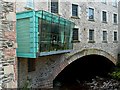
The Hawick Hub and the Beanscene
This café bar has a cantilevered sitting and viewing area over the Slitrig Water in Hawick. This was viewed from Drumlanrig Bridge.
Image: © Walter Baxter
Taken: 30 Jun 2012
0.01 miles