IMAGES TAKEN NEAR TO
KELSO, TD5 8EE
Introduction
This page details the photographs taken nearby to TD5 8EE by members of the Geograph project.
The Geograph project started in 2005 with the aim of publishing, organising and preserving representative images for every square kilometre of Great Britain, Ireland and the Isle of Man.

There are currently over 7.5m images from over14,400 individuals and you can help contribute to the project by visiting https://www.geograph.org.uk
Image Map
Images are licensed for reuse under creativecommons.org/licenses/by-sa/2.0
Notes
- Clicking on the map will re-center to the selected point.
- The higher the marker number, the further away the image location is from the centre of the postcode.
Image Listing (15 Images Found)
Images are licensed for reuse under creativecommons.org/licenses/by-sa/2.0
Image
Details
Distance
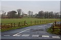
1
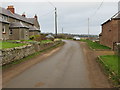
Minor road at Caverton Mill
Looking north-eastward.
Image: © Peter Wood
Taken: 12 Dec 2018
0.02 miles
2
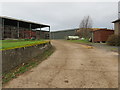
Track through farm buildings at Caverton Mill
Looking north-westward.
Image: © Peter Wood
Taken: 12 Dec 2018
0.03 miles
3
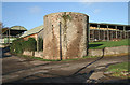
Caverton Mill
Farm buildings with the remains of a windmill in the foreground. The circular stone base survives and it is believed to be only one of two windmills in the Scottish Borders area, the other being near Kippilaw Image
Image: © Walter Baxter
Taken: 24 Oct 2008
0.04 miles
4
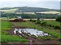
Fields at Caverton Mill
The low lying floodplain of the Kale Water in the foreground was once part of Linton Loch, an extensive stretch of water which was only finally drained in the 18th century. The mast on the skyline is on Linton Hill Image
Image: © Oliver Dixon
Taken: 2 Aug 2012
0.06 miles
5
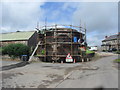
Renovation work at Caverton Mill
On the old windmill.
Image: © James Denham
Taken: 8 Jul 2012
0.07 miles
6
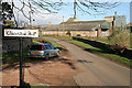
The road by Caverton Mill
Caverton Mill is a farm on the northeast side of the Kale Water. The road is in NT7425 while the buildings in the background are in NT7525.
Image: © Walter Baxter
Taken: 26 Oct 2008
0.09 miles
7
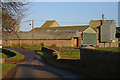
Caverton Mill
The bridge is in this square but the gridline goes through the farm buildings.
Image: © Anne Burgess
Taken: 1 Jan 2018
0.10 miles
8
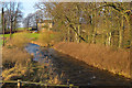
Kale Water at Caverton Mill
Looking downstream from beside the road bridge.
Image: © Anne Burgess
Taken: 1 Jan 2018
0.12 miles
10
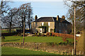
Caverton Mill Farm House
An elegantly symmetrical house close to the Kale Water. It looks Georgian but could be later; there are some similar houses built in the mid-19th century.
Image: © Anne Burgess
Taken: 1 Jan 2018
0.13 miles