IMAGES TAKEN NEAR TO
Nut Tree Close, HIGHBRIDGE, TA9 3PN
Introduction
This page details the photographs taken nearby to Nut Tree Close, TA9 3PN by members of the Geograph project.
The Geograph project started in 2005 with the aim of publishing, organising and preserving representative images for every square kilometre of Great Britain, Ireland and the Isle of Man.

There are currently over 7.5m images from over14,400 individuals and you can help contribute to the project by visiting https://www.geograph.org.uk
Image Map
Images are licensed for reuse under creativecommons.org/licenses/by-sa/2.0
Notes
- Clicking on the map will re-center to the selected point.
- The higher the marker number, the further away the image location is from the centre of the postcode.
Image Listing (10 Images Found)
Images are licensed for reuse under creativecommons.org/licenses/by-sa/2.0
Image
Details
Distance
2
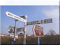
Direction Sign - Signpost on the B3141 Church Road in East Huntspill
Pyramid finial - 3 arms; Somerset SCC pyramid by the B3141, in parish of East Huntspill (Sedgemoor District), on the northeast side of the crossroads of the B3141 Church Road, New Road and Hackness Road.
surveyed
Milestone Society National ID: SO_ST3445
Image: © Milestone Society
Taken: Unknown
0.06 miles
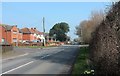
3

At Church Road crossroads
The main road through East Huntspill is well posted.
Image: © Neil Owen
Taken: 30 Dec 2020
0.06 miles
4
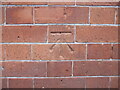
Benchmark on East Huntspill School
A cutmark resides on the wall of the school. See https://www.bench-marks.org.uk/bm138507 for the entry in the Benchmark Database or Image] for a wider view of the school yard.
Image: © Neil Owen
Taken: 30 Dec 2020
0.09 miles
5
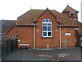
East Huntspill Primary School
The village school dates from the 1890s and has a post-war benchmark on the wall - it's just about in the short leg position for a right-handed batsman. See Image
Image: © Neil Owen
Taken: 30 Dec 2020
0.09 miles
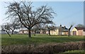
7

East Huntspill recreation ground
Right next to the school and offering grass pitches, enclosed courts and children's play equipment.
Image: © Neil Owen
Taken: 30 Dec 2020
0.15 miles
8
Church Road (B3141), East Huntspill
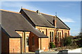
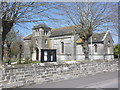
Beyond the houses on the left, and partly behind a tree, is the grey lias of All Saints Church, built in 1839 https://www.historicengland.org.uk/listing/the-list/list-entry/1060130 .
Image: © Derek Harper
Taken: 13 Mar 2016
0.16 miles
9
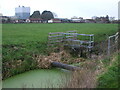
The field south of the Brue
Looking northeastwards across Moor Row and one of the many drainage channels here abouts. Across the River Brue is part of the former milk processing factory, now a multi-business industrial estate.
Image: © Neil Owen
Taken: 30 Dec 2020
0.18 miles
10
B3141 in East Huntspill
Houses on Church Road just south of Bason Bridge, seen across an orchard from Merry Lane.
Image: © Derek Harper
Taken: 13 Mar 2016
0.25 miles