1
Delivery office
The Royal Mail delivery offices in Friarn Street, still brooding over recent industrial action.
Image: © Neil Owen
Taken: 5 Sep 2013
0.01 miles
2
Ordnance Survey Cut Mark
This OS cut mark can be found on No28a Friarn Street. It marks a point 10.9058m above mean sea level.
Image: © Adrian Dust
Taken: 19 Oct 2015
0.02 miles
3
Friarn Street
An unassuming row of terraced houses, but the nearest has a benchmark. See
Image
Image: © Neil Owen
Taken: 5 Sep 2013
0.02 miles
4
Friarn Street benchmark
A cutmark in the brickwork of number . The yellow crayon marks indicate that it had been used in the more recent past. See
Image] for a wider view and http://www.bench-marks.org.uk/bm51988 for the entry in the Benchmark Database.
Image: © Neil Owen
Taken: 5 Sep 2013
0.02 miles
5
Friarn Street, Bridgwater
On the right is the Quaker Meeting house, originally built in 1722 and since altered http://webapp1.somerset.gov.uk/her/details.asp?prn=14866 . Numbers 13 and 15 on the left are also listed http://webapp1.somerset.gov.uk/her/details.asp?prn=14872 and http://webapp1.somerset.gov.uk/her/details.asp?prn=14873 .
Image: © Derek Harper
Taken: 26 Jan 2010
0.03 miles
6
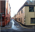
Corner of Friarn Street and Horsepond Lane, Bridgwater
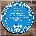
A blue plaque http://www.geograph.org.uk/photo/3348565 on the wall shows that Horsepond Lane was recorded
as Wayhure in 1268, the oldest recorded named street in Bridgwater.
Image: © Jaggery
Taken: 4 Oct 2012
0.03 miles
7
Horsepond Lane blue plaque, Bridgwater
The Bridgwater & District Civic Society plaque is on the wall here. http://www.geograph.org.uk/photo/3348553
Image: © Jaggery
Taken: 4 Oct 2012
0.03 miles
8
Silver Street, Bridgwater
Viewed from St Mary Street looking south along Silver Street towards Friarn Street. A Bridgwater & District blue plaque on a wall records that Silver Street was known in the 14th century as "The Way from the Church to the House of the Friars minor", wherein dwelt Franciscan friars until dissolution in 1538.
Image: © Jaggery
Taken: 4 Oct 2012
0.04 miles
9
Those aren't white lines
These marks in Horsepond Lane (formerly the Wayhure) are in fact granite markers that point to some of Bridgwater's past. In the thirteenth century the lane was a lot narrower; however, the marks are also thought to indicate the eastern extent of the former Franciscan Friary, which was here until the Dissolution in 1538.
The lane was only widened in 2008.
Image: © Neil Owen
Taken: 5 Sep 2013
0.04 miles
10
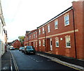
Modern housing in a medieval street, Bridgwater
The recently-built housing in Wyndham Mews is at the SW end of Silver Street,
which dates back to at least the 14th century. http://www.geograph.org.uk/photo/3309733
Image: © Jaggery
Taken: 4 Oct 2012
0.05 miles


