IMAGES TAKEN NEAR TO
Upton, TAUNTON, TA4 2HU
Introduction
This page details the photographs taken nearby to TA4 2HU by members of the Geograph project.
The Geograph project started in 2005 with the aim of publishing, organising and preserving representative images for every square kilometre of Great Britain, Ireland and the Isle of Man.

There are currently over 7.5m images from over14,400 individuals and you can help contribute to the project by visiting https://www.geograph.org.uk
Image Map
Images are licensed for reuse under creativecommons.org/licenses/by-sa/2.0
Notes
- Clicking on the map will re-center to the selected point.
- The higher the marker number, the further away the image location is from the centre of the postcode.
Image Listing (42 Images Found)
Images are licensed for reuse under creativecommons.org/licenses/by-sa/2.0
Image
Details
Distance
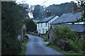
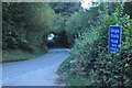
1
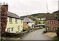
Bridge End
Looking in the opposite direction to Image In the background on the hillside are cottages on the B3190. The lane forms the boundary of the Exmoor National Park (right).
Image: © Derek Harper
Taken: 6 Apr 2014
0.00 miles

3
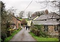
Bridge End
In the foreground are the parapets of the bridge carrying Hansetown Road over the River Haddeo. The lane, which forms the boundary of the Exmoor National Park (left), passes cottages before climbing towards Henstown.
Image: © Derek Harper
Taken: 6 Apr 2014
0.01 miles
4
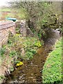
River Haddeo at Bridge End
Looking upstream from the bridge on Hansetown Road shown in Image, with bright kingcups (Caltha palustris) enlivening the gloom.
Image: © Derek Harper
Taken: 6 Apr 2014
0.02 miles
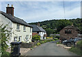
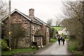
6
Upton : Country Lane
A small lane heading through the small settlement of Upton.
Image: © Lewis Clarke
Taken: 13 Sep 2014
0.03 miles
7
Bridge End
In the background is the scene in Image The lane forms the boundary of the Exmoor National Park (left).
Image: © Derek Harper
Taken: 6 Apr 2014
0.03 miles
8
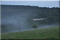
Upton : Grassy Field
A grassy field and misty evening in Upton.
Image: © Lewis Clarke
Taken: 13 Sep 2014
0.06 miles
9
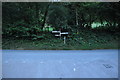
Upton : The B3190
The B3190 seen at the road junction with Hansetown Road.
Image: © Lewis Clarke
Taken: 13 Sep 2014
0.09 miles
10
Upton : The B3190
A road heading between Bampton and Watchet.
Image: © Lewis Clarke
Taken: 13 Sep 2014
0.09 miles