IMAGES TAKEN NEAR TO
Bathealton, TAUNTON, TA4 2AH
Introduction
This page details the photographs taken nearby to TA4 2AH by members of the Geograph project.
The Geograph project started in 2005 with the aim of publishing, organising and preserving representative images for every square kilometre of Great Britain, Ireland and the Isle of Man.

There are currently over 7.5m images from over14,400 individuals and you can help contribute to the project by visiting https://www.geograph.org.uk
Image Map
Images are licensed for reuse under creativecommons.org/licenses/by-sa/2.0
Notes
- Clicking on the map will re-center to the selected point.
- The higher the marker number, the further away the image location is from the centre of the postcode.
Image Listing (11 Images Found)
Images are licensed for reuse under creativecommons.org/licenses/by-sa/2.0
Image
Details
Distance

2
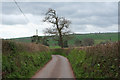
Bathealton: lane to Manworthy Cross
Looking south west in the direction of Bathealton
Image: © Martin Bodman
Taken: 17 Apr 2006
0.11 miles
3
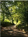
Lane at Blackberry Barn
The lane to Bathealton about 100 metres further down from Image, twisting downhill amongst trees to meet the lane from Sminhay Bridge.
Image: © Derek Harper
Taken: 29 Sep 2009
0.12 miles
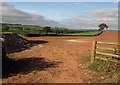
5
Lane to Bathealton
The lane shown in Image starts to drop more steeply between rising banks and trees. Glimpsed ahead is Woodlands Farm, in Image
Image: © Derek Harper
Taken: 29 Sep 2009
0.13 miles
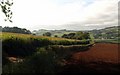
7
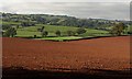
Fields northeast of Bathealton
From the same spot as Image, and looking across the ploughed field shown in Image This low area between hills forms a watershed between the Tone and the Hillfarrance Brook - which ends up in the Tone anyway.
Image: © Derek Harper
Taken: 29 Sep 2009
0.15 miles
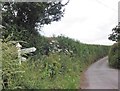
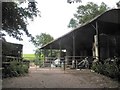
8
Debris and gateway near Bathealton
Well, it had to go somewhere. This is a view across the western corner of Image (also shown in Image), seen from the lane shown in Image
Image: © Derek Harper
Taken: 29 Sep 2009
0.15 miles
9
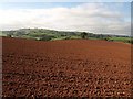
Ploughed field near Cobhay Farm
The footpath described in Image continues along the edge of this undulating ploughed field, with a view across to the ridge between valleys of the Tone and the Hillfarrance Brook.
Image: © Derek Harper
Taken: 29 Sep 2009
0.21 miles
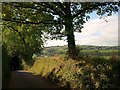
10
Lane past Milverton Wood
The shadow and the twig belong to the northwest corner of the wood, which is on the other side of the lane. The lane descends towards Bathealton.
Image: © Derek Harper
Taken: 29 Sep 2009
0.22 miles