IMAGES TAKEN NEAR TO
Gatchell Green, TAUNTON, TA3 7ER
Introduction
This page details the photographs taken nearby to Gatchell Green, TA3 7ER by members of the Geograph project.
The Geograph project started in 2005 with the aim of publishing, organising and preserving representative images for every square kilometre of Great Britain, Ireland and the Isle of Man.

There are currently over 7.5m images from over14,400 individuals and you can help contribute to the project by visiting https://www.geograph.org.uk
Image Map
Images are licensed for reuse under creativecommons.org/licenses/by-sa/2.0
Notes
- Clicking on the map will re-center to the selected point.
- The higher the marker number, the further away the image location is from the centre of the postcode.
Image Listing (139 Images Found)
Images are licensed for reuse under creativecommons.org/licenses/by-sa/2.0
Image
Details
Distance
1
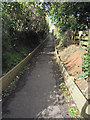
Poke ( Pook ) Lane-Trull
Forms the end of the footpath from Spearcey Lane to
Trull. In earlier years the trees overhung the lane to form a tunnel. It is all much tidier now.
Image: © Nick Chipchase
Taken: 21 Sep 2011
0.04 miles

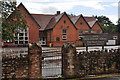
4
Trull old village hall
Soon to be demolished.
Image: © Nick Chipchase
Taken: 21 May 2013
0.06 miles
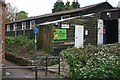
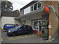
5
Trull : Trull Church of England School
"Trull Primary School caters for children aged 4-11 years. As a Voluntary Aided school the church is represented by a majority of the Governors and the teaching staff are in sympathy with the Christian faith as expressed by the Church of England." - www.trullprimary.com
Image: © Lewis Clarke
Taken: 23 Aug 2015
0.07 miles
6
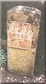
Old Milestone, Honiton Road, Trull
The milestone is located at the junction with Wyatts Field, on the pavement against the garden wall, on the east side of road. Parish of Trull (Taunton Dean District). Metal plate attached to stone post, Taunton roll top iron plate design, erected by the Taunton turnpike trust in the 19th century.
Inscription reads:-
2
MILES
To
TAUNTON
Carved benchmark lower front face.
Grade II listed. List Entry Number: 1252522
https://historicengland.org.uk/listing/the-list/list-entry/1252522
Milestone Society National ID: SO_TATL02
Image: © JR Dowding
Taken: 1 Jan 2001
0.08 miles
8
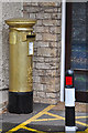
Trull : Post Box
Deb Criddle, 46, from Trull, near Taunton, won a team gold and two individual silvers in the Paralympics.
Image: © Lewis Clarke
Taken: 23 Aug 2015
0.09 miles

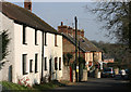
10
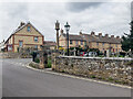
Church Road/Wild Oak Lane
Junction of Church Road and Wild Oak Lane with the corner of All Saint's Churchyard in the foreground. In the centre of the photo is Trull War Memorial, unveiled on 19 September 1920 and grade II listed - see https://historicengland.org.uk/listing/the-list/list-entry/1434658?section=official-list-entry. The houses in the background are marked on the 1887 6 inch map.
Image: © Ian Capper
Taken: 14 Apr 2022
0.09 miles