IMAGES TAKEN NEAR TO
West Street, SOUTH PETHERTON, TA13 5DJ
Introduction
This page details the photographs taken nearby to West Street, TA13 5DJ by members of the Geograph project.
The Geograph project started in 2005 with the aim of publishing, organising and preserving representative images for every square kilometre of Great Britain, Ireland and the Isle of Man.

There are currently over 7.5m images from over14,400 individuals and you can help contribute to the project by visiting https://www.geograph.org.uk
Image Map
Images are licensed for reuse under creativecommons.org/licenses/by-sa/2.0
Notes
- Clicking on the map will re-center to the selected point.
- The higher the marker number, the further away the image location is from the centre of the postcode.
Image Listing (27 Images Found)
Images are licensed for reuse under creativecommons.org/licenses/by-sa/2.0
Image
Details
Distance
1
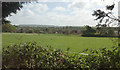
Towards Broadmead
From Whitfield Lane as it runs past the trees shown in Image The nearer houses across the fields are along West Street.
Image: © Derek Harper
Taken: 27 Apr 2019
0.07 miles
2
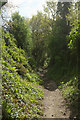
Partway Lane
A sunken track carrying bridleway 40UD100 Y 24/38, heading towards Parkway Farm at West Street, and seen from its junction with Whitfield Lane.
Image: © Derek Harper
Taken: 27 Apr 2019
0.08 miles
3
Whitfield Lane, South Petherton
A reverse view of Image] along footpath 40UD100 Y 24/87, with a distant view of the church at South Petherton.
Image: © Derek Harper
Taken: 27 Apr 2019
0.08 miles
4
Whitfield Lane, South Petherton
The lane is no more than a wide area of vegetation between fields, but re-establishes itself at the bushes ahead, where it, and footpath 40UD100 Y 24/87, plunge down to the meet the sunken Partway Lane, running at right angles.
Image: © Derek Harper
Taken: 27 Apr 2019
0.10 miles
5
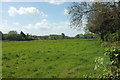
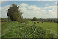
Field near Broadmead
Looking right from where Image] was taken. Houses on West Street are on the left.
Image: © Derek Harper
Taken: 27 Apr 2019
0.10 miles
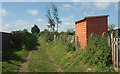
6
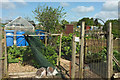
AONB, Allotments, Whitfield Lane, South Petherton
A notice at the entrance to this allotment reads "Area of Outstanding Natural Beauty", and it's hard to argue with that, even though many of the features are man-made.
Image: © Derek Harper
Taken: 27 Apr 2019
0.11 miles
7
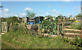
Allotments, Whitfield Lane, South Petherton
Taken by the hut seen in Image Some good produce being grown here.
Image: © Derek Harper
Taken: 27 Apr 2019
0.12 miles
8
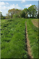
Path to Broadmead
Taken further down footpath 40UD100 Y 24/37, with a view opening up to the right.
Image: © Derek Harper
Taken: 27 Apr 2019
0.12 miles
9

Path to Broadmead
Footpath 40UD100 Y 24/37 seen from Whitfield Lane. It leads to West Street in the South Petherton suburb of Broadmead. Can a village have a suburb? Perhaps South Petherton is a small town.
Image: © Derek Harper
Taken: 27 Apr 2019
0.13 miles
10
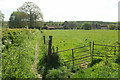
Whitfield Lane, South Petherton
Footpath 40UD100 Y 24/87 runs along the southeast edge of the village's allotments.
Image: © Derek Harper
Taken: 27 Apr 2019
0.14 miles