IMAGES TAKEN NEAR TO
Lightgate Lane, SOUTH PETHERTON, TA13 5AU
Introduction
This page details the photographs taken nearby to Lightgate Lane, TA13 5AU by members of the Geograph project.
The Geograph project started in 2005 with the aim of publishing, organising and preserving representative images for every square kilometre of Great Britain, Ireland and the Isle of Man.

There are currently over 7.5m images from over14,400 individuals and you can help contribute to the project by visiting https://www.geograph.org.uk
Image Map
Images are licensed for reuse under creativecommons.org/licenses/by-sa/2.0
Notes
- Clicking on the map will re-center to the selected point.
- The higher the marker number, the further away the image location is from the centre of the postcode.
Image Listing (58 Images Found)
Images are licensed for reuse under creativecommons.org/licenses/by-sa/2.0
Image
Details
Distance
1

Diamond Jubilee fountain, South Petherton
Image: © Nick Chipchase
Taken: 19 Jun 2015
0.07 miles
2
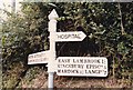
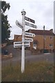
Direction Sign ? Signpost
Located on the northwest side of the junction of Lightgate Road and Harvey's Road in South Petherton parish. 3 arms (now 4 arms) and pyramid finial.
See 2009 photo https://www.geograph.org.uk/photo/6099091.
See also http://www.flickr.com/photos/tollhouses/3886069961 and http://www.flickr.com/photos/13171205@N08/8371983216.
Milestone Society National ID: SO_ST4316
Image: © W Marsh
Taken: Unknown
0.09 miles
3
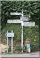
Direction Sign - Signpost by Harvey's Road, South Petherton
Pyramid finial - 4 arms; Somerset SCC pyramid by the UC road, in parish of South Petherton (South Somerset District), Lightgate Road junction with Harvey's Road, mini-roundabout, against stone wall.
1986 photo https://www.geograph.org.uk/photo/6591408 with arm missing.
Grade II listed.
List Entry Number: 1178129 https://historicengland.org.uk/listing/the-list/list-entry/1178129
Surveyed
Milestone Society National ID: SO_ST4316
Image: © Alan Rosevear
Taken: 3 Sep 2009
0.09 miles
4
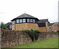
St Michael's RC Church, South Petherton
Built in 1961.
Image: © Bill Harrison
Taken: 15 Jul 2016
0.11 miles
5
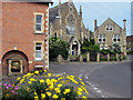
St James Street, South Petherton
And the David Hall Arts Centre
Image: © Ken Grainger
Taken: 10 May 2006
0.11 miles
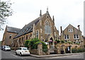
6
David Hall, South Petherton
An old chapel now used as a performing arts centre
Image: © Ken Grainger
Taken: 10 May 2006
0.12 miles
7
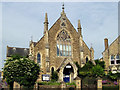
David Hall, South Petherton
The former Congregational Church dating from 1863: now the village community hall and arts centre. Grade II listed: http://www.britishlistedbuildings.co.uk/101345893-former-united-reform-church-south-petherton#.WYS0aiaWyAg . The former Sunday School to the right.
Image: © Bill Harrison
Taken: 15 Jul 2016
0.14 miles
8
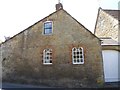
Building on Harvey's Road, South Petherton
There is a fire hydrant plate and benchmark on this building. The benchmark is located underneath the yellow fire hydrant plate. For full description, see
http://www.bench-marks.org.uk/bm67102. See also Image
Image: © Becky Williamson
Taken: 28 May 2015
0.14 miles
9
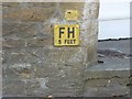
Fire hydrant plate and benchmark, Harveys Road, South Petherton
Ordnance Survey benchmark, described on database at http://www.bench-marks.org.uk/bm67102. See also Image
Image: © Becky Williamson
Taken: 28 May 2015
0.14 miles
10
Old Direction Sign - Signpost by Silver Street, South Petherton
Pyramid finial - 4 arms; Somerset SCC pyramid (Sheldon) by the UC road, in parish of South Petherton (South Somerset District), Silver Street junction with Lightgate Road.
Surveyed
Milestone Society National ID: SO_ST4317B
Image: © Milestone Society
Taken: Unknown
0.14 miles