IMAGES TAKEN NEAR TO
Castle Street, TA11 6FU
Introduction
This page details the photographs taken nearby to Castle Street, TA11 6FU by members of the Geograph project.
The Geograph project started in 2005 with the aim of publishing, organising and preserving representative images for every square kilometre of Great Britain, Ireland and the Isle of Man.

There are currently over 7.5m images from over14,400 individuals and you can help contribute to the project by visiting https://www.geograph.org.uk
Image Map
Images are licensed for reuse under creativecommons.org/licenses/by-sa/2.0
Notes
- Clicking on the map will re-center to the selected point.
- The higher the marker number, the further away the image location is from the centre of the postcode.
Image Listing (10 Images Found)
Images are licensed for reuse under creativecommons.org/licenses/by-sa/2.0
Image
Details
Distance
1
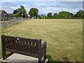
A nice bench for watching the sport in Keinton Mandeville
Image: © Rob Purvis
Taken: 23 Jul 2022
0.04 miles
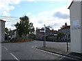
2
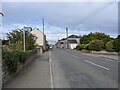
Road heading west through Keinton Mandeville
Image: © Rob Purvis
Taken: 23 Jul 2022
0.07 miles
3
Off the main road
Babcary Lane runs south off Castle Street, the main street of Keinton Mandeville.
Image: © Neville Goodman
Taken: 4 Aug 2007
0.12 miles
4
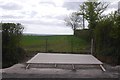
Construction, Keinton Mandeville
A new concrete base beside the B3153. Not exciting, but better here than some blurry stuff taken from a fast train which might just actually be within the square.
No idea what is being built, but it will be there now.
Image: © Richard Webb
Taken: 10 Apr 2017
0.18 miles
5
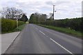
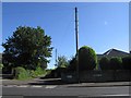
B3153, Keinton Mandeville
Heading towards the Fosse Way.
Image: © Richard Webb
Taken: 10 Apr 2017
0.21 miles
6
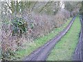
Footpath near Keinton Mandeville
The footpath takes walkers from a minor road to the village of Keinton Mandeville.
Image: © Maigheach-gheal
Taken: 5 Feb 2010
0.23 miles
7
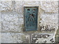
Ordnance Survey Flush Bracket 10718
This can be found on the wall of a house in Keinton Mandeville.
For more detail see : http://www.bench-marks.org.uk/bm18781
Image: © Peter Wood
Taken: 30 Mar 2014
0.23 miles
8
Old Direction Sign - Signpost by the B3153, High Street, Keinton Mandeville parish
Pyramid finial - 4 arms, 1 missing; Somerset SCC pyramid by the B3153, in parish of Keinton Mandeville (South Somerset District), High Street junction with Combe Hill. N.B. Adjacent building redeveloped and signpost apparently broken off and missing from Streetview April 2021.
Surveyed
Milestone Society National ID: SO_ST5430
Image: © Milestone Society
Taken: Unknown
0.23 miles
9
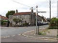
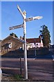
Crossroads Keinton Mandeville
This shows the junction where Queen St and Coombe hill meet the main road the B3153 consisting of High St and Castle St. The sign post shows the direction for Babcary , Kingweston , Somerton, The Church and the Village Hall
Image: © Nigel Mykura
Taken: 18 Sep 2011
0.24 miles