IMAGES TAKEN NEAR TO
Fayrefield, SOMERTON, TA11 6AL
Introduction
This page details the photographs taken nearby to Fayrefield, TA11 6AL by members of the Geograph project.
The Geograph project started in 2005 with the aim of publishing, organising and preserving representative images for every square kilometre of Great Britain, Ireland and the Isle of Man.

There are currently over 7.5m images from over14,400 individuals and you can help contribute to the project by visiting https://www.geograph.org.uk
Image Map (Loading...)


Getting Data...Please wait
Leaflet Map data © OpenStreetMap
Images are licensed for reuse under creativecommons.org/licenses/by-sa/2.0
Notes
- Clicking on the map will re-center to the selected point.
- The higher the marker number, the further away the image location is from the centre of the postcode.
Image Listing (18 Images Found)
Images are licensed for reuse under creativecommons.org/licenses/by-sa/2.0
Image
Details
Distance
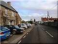
2
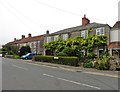
High Street, Keinton Mandeville
The B3153 passing the Quarry Inn. Limestone quarrying still takes place in Keinton Mandeville.
Image: © Richard Webb
Taken: 10 Apr 2017
0.04 miles
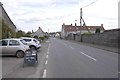
3
Bus shelter in Keinton Mandeville
On the main road through the village (B3153). Most of the village houses are to the south of the road
Image: © David Smith
Taken: 17 Nov 2017
0.04 miles
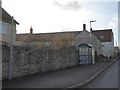
4

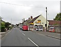
The Quarry Inn, Keinton Mandeville
The car in front is not typical of rural transport in this part of Somerset. There is a bus shelter beyond the inn. To the south of this road is the stone quarry Image from which the inn takes its name
Image: © David Smith
Taken: 17 Nov 2017
0.05 miles
8
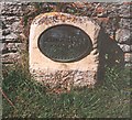
Old Milestone by the B3153, Main Street, Keinton Mandeville Parish
Millennium metal plate attached to old stone post by the B3153, in parish of KEINTON MANDEVILLE (SOUTH SOMERSET District), Main Street, Keinton Mandeville, on grass verge in front of stone wall, on North side of road. LSCC iron plate, originally erected by the Langport, Somerton & Castle Cary turnpike trust in the 19th century.
Inscription reads:-
CASTLE CARY 6
SOMERTON 4
KM AD 2000
Somerset HER listed
HER number: 14196 https://www.heritagegateway.org.uk/Gateway/Results_Single.aspx?uid=14196&resourceID=100
Milestone Society National ID: SO_CCSO06.
Image: © JR Dowding
Taken: 12 Aug 2002
0.07 miles
10
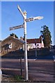
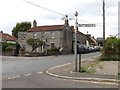
Old Direction Sign - Signpost by the B3153, High Street, Keinton Mandeville parish
Pyramid finial - 4 arms, 1 missing; Somerset SCC pyramid by the B3153, in parish of Keinton Mandeville (South Somerset District), High Street junction with Combe Hill. N.B. Adjacent building redeveloped and signpost apparently broken off and missing from Streetview April 2021.
Surveyed
Milestone Society National ID: SO_ST5430
Image: © Milestone Society
Taken: Unknown
0.08 miles