IMAGES TAKEN NEAR TO
SY8 9SU
Introduction
This page details the photographs taken nearby to SY8 9SU by members of the Geograph project.
The Geograph project started in 2005 with the aim of publishing, organising and preserving representative images for every square kilometre of Great Britain, Ireland and the Isle of Man.

There are currently over 7.5m images from over14,400 individuals and you can help contribute to the project by visiting https://www.geograph.org.uk
Image Map
Images are licensed for reuse under creativecommons.org/licenses/by-sa/2.0
Notes
- Clicking on the map will re-center to the selected point.
- The higher the marker number, the further away the image location is from the centre of the postcode.
Image Listing (1193 Images Found)
Images are licensed for reuse under creativecommons.org/licenses/by-sa/2.0
Image
Details
Distance
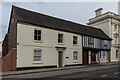
1
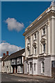
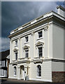
Stone House
Former offices of South Shropshire District Council, until the council was abolished in 2009 with the area becoming the responsibility of the new Shropshire unitary authority. It was converted to residential use in 2011.
It was originally built in the 18th century, and the stucco front was added in around 1840 (obscuring not just the front but also the relevance of the building's name!). It is grade II* listed - see www.historicengland.org.uk/listing/the-list/list-entry/1281966.
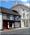
The buildings beyond are all grade II listed: no 112 (the half timbered building), 16th century with later additions, see www.historicengland.org.uk/listing/the-list/list-entry/1221213; no 111 (connected to it, but of different construction being white painted brick), 18th century with earlier origins - see www.historicengland.org.uk/listing/the-list/list-entry/1290614; and no 110 (the taller building in the background, with chimneys), similarly constructed and again dating from the 18th century with earlier additions - see www.historicengland.org.uk/listing/the-list/list-entry/1282021.
Image: © Ian Capper
Taken: 10 Apr 2012
0.01 miles
2
Stone House
Former offices of South Shropshire District Council, until the council was abolished in 2009 with the area becoming the responsibility of the new Shropshire unitary authority. It was converted to residential use in 2011.
It was originally built in the 18th century, and the stucco front was added in around 1840 (obscuring not just the front but also the relevance of the building's name!). It is grade II* listed - see www.historicengland.org.uk/listing/the-list/list-entry/1281966.
To its left is 112 Corve Street, 16th century with later additions and grade II listed - see www.historicengland.org.uk/listing/the-list/list-entry/1221213.
Image: © Ian Capper
Taken: 16 Feb 2018
0.01 miles
3
Stone House
Former offices of South Shropshire District Council, until the council was abolished in 2009 with the area becoming the responsibility of the new Shropshire unitary authority. It was converted to residential use in 2011.
It was originally built in the 18th century, and the stucco front was added in around 1840 (obscuring not just the front but also the relevance of the building's name!). It is grade II* listed - see www.historicengland.org.uk/listing/the-list/list-entry/1281966.
Image: © Ian Capper
Taken: 16 Feb 2018
0.01 miles
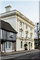
4
Stone House, Ludlow
Originally a house, the 3-storey building in Corve Street was in use as Shropshire Council offices at the August 2012 date of this view. In early 2014, it was reported that Shropshire Council were to sell the building which had become significantly underused. A review showed that the running and maintenance of the building was not giving good value for money and that the remaining staff and functions could be relocated to other council buildings in the area.
Stone House was Grade II* listed in 1954.
Image: © Jaggery
Taken: 22 Aug 2012
0.01 miles
5
112 Corve Street, Ludlow
16th century timber-frame house with later alterations. Grade II listed in 1954.
The white 3-storey Stone House http://www.geograph.org.uk/photo/3974016 on the right is Grade II* listed.
Image: © Jaggery
Taken: 22 Aug 2012
0.01 miles
6
Stone House, Ludlow
A clearer view of the fine building on Corve Street also seen in Image
Image: © Derek Harper
Taken: 3 Jan 2009
0.01 miles
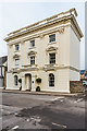
7
Stone House, Corve Street, Ludlow
A rich confection of stucco, Corinthian pilasters, pediments and pilasters. Externally, at least, c1840. Grade II* listed.
In the not-too-distant past this has served as council offices and retail premises, but has now reverted to a private dwelling I believe. (At the time of writing, December 2018, the six-bedroom house was under offer, guide price £975k, a steal to anyone used to London.)
Image: © Stephen Richards
Taken: 14 May 2014
0.01 miles
8
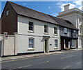
111 Corve Street, Ludlow
18th century house (with earlier origins) now in use as offices. Grade II listed in 1969.
The two buildings in the background are also listed. The black and white building http://www.geograph.org.uk/photo/3974085 at 112 Corve Street is Grade II listed. Stone House http://www.geograph.org.uk/photo/3974016 is Grade II* listed.
Image: © Jaggery
Taken: 22 Aug 2012
0.01 miles
9
111-112 Corve Street
Pair of buildings on Corve Street, both grade II listed. On the left is no 111 - 18th century with earlier origins - see www.historicengland.org.uk/listing/the-list/list-entry/1290614 and on the right is no 112 (the half timbered building), 16th century with later additions, see www.historicengland.org.uk/listing/the-list/list-entry/1221213.
Image: © Ian Capper
Taken: 16 Feb 2018
0.02 miles
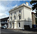
10
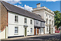
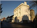
111 & 112 Corve Street and The Stone House
Houses on the east side of Corve Street. Nearest is no 111, dating from the 18th century with earlier origins, and next to it is no 112, 16th century with later additions. Both are grade II listed - see www.historicengland.org.uk/listing/the-list/list-entry/1290614 and www.historicengland.org.uk/listing/the-list/list-entry/1221213 respectively.
Beyond is The Stone House, which housed the offices of South Shropshire District Council until the council was abolished in 2009 with the area becoming the responsibility of the new Shropshire unitary authority. It was converted to residential use in 2011. It was originally built in the 18th century, and the stucco front was added in around 1840 (obscuring not just the front but also the relevance of the building's name!). It is grade II* listed - see www.historicengland.org.uk/listing/the-list/list-entry/1281966. www.historicengland.org.uk/listing/the-list/list-entry/1221213.
Image: © Ian Capper
Taken: 2 Aug 2020
0.02 miles