Stone House
Introduction
The photograph on this page of Stone House by Ian Capper as part of the Geograph project.
The Geograph project started in 2005 with the aim of publishing, organising and preserving representative images for every square kilometre of Great Britain, Ireland and the Isle of Man.

There are currently over 7.5m images from over 14,400 individuals and you can help contribute to the project by visiting https://www.geograph.org.uk
Stone House
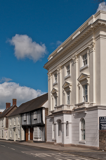
Image: © Ian Capper Taken: 10 Apr 2012
Former offices of South Shropshire District Council, until the council was abolished in 2009 with the area becoming the responsibility of the new Shropshire unitary authority. It was converted to residential use in 2011. It was originally built in the 18th century, and the stucco front was added in around 1840 (obscuring not just the front but also the relevance of the building's name!). It is grade II* listed - see www.historicengland.org.uk/listing/the-list/list-entry/1281966. The buildings beyond are all grade II listed: no 112 (the half timbered building), 16th century with later additions, see www.historicengland.org.uk/listing/the-list/list-entry/1221213; no 111 (connected to it, but of different construction being white painted brick), 18th century with earlier origins - see www.historicengland.org.uk/listing/the-list/list-entry/1290614; and no 110 (the taller building in the background, with chimneys), similarly constructed and again dating from the 18th century with earlier additions - see www.historicengland.org.uk/listing/the-list/list-entry/1282021.
Images are licensed for reuse under creativecommons.org/licenses/by-sa/2.0
Image Location
Latitude
52.371717
Longitude
-2.719235