IMAGES TAKEN NEAR TO
Caynham, LUDLOW, SY8 4JY
Introduction
This page details the photographs taken nearby to SY8 4JY by members of the Geograph project.
The Geograph project started in 2005 with the aim of publishing, organising and preserving representative images for every square kilometre of Great Britain, Ireland and the Isle of Man.

There are currently over 7.5m images from over14,400 individuals and you can help contribute to the project by visiting https://www.geograph.org.uk
Image Map
Images are licensed for reuse under creativecommons.org/licenses/by-sa/2.0
Notes
- Clicking on the map will re-center to the selected point.
- The higher the marker number, the further away the image location is from the centre of the postcode.
Image Listing (16 Images Found)
Images are licensed for reuse under creativecommons.org/licenses/by-sa/2.0
Image
Details
Distance
1
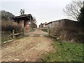
Poughnhill Farm
Poughnhill Farm from public footpath from Caynham Hill fort to Ledwyche Brook Crossing. A short public footpath, 0514/19A/11, projects through the gate for a short distance into the farm, and then stops (so far as the definitive map is concerned).
Image: © Hugh Craddock
Taken: 11 Mar 2015
0.04 miles
2
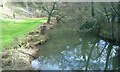
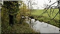
Ledwyche Brook Poughn Hill
Ledwyche Brook, (Ledwich) a minor river. Good fishing can be had.
Image: © Ralph Beardmore
Taken: 19 Feb 2019
0.09 miles
3
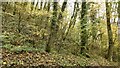
East end of the Tinker's Hill ridge
A Silurian limestone ridge, mostly wooded. Here the Ledwyche Brook flows through it with Caynham Camp on the opposite side.
Image: © Richard Webb
Taken: 18 Nov 2021
0.12 miles
4
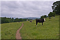
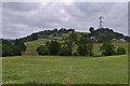
Below Caynham Hill
Looking east along the northern slope of Caynham Hill. In the left distance is Titterstone Clee Hill.
Image: © Ian Capper
Taken: 21 Jul 2013
0.13 miles
5
Ledwyche Brook
Tributary of the Teme seen from Sheet Road.
Image: © Richard Webb
Taken: 18 Nov 2021
0.13 miles
6
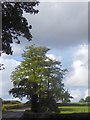
Tree by Sheet road at Poughnhill
An isolated tree on the north at the point where the road leaves the woodland of the stream valley
Image: © David Smith
Taken: 29 Sep 2016
0.14 miles
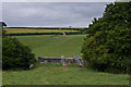
7
Towards Caynham Hill
Looking towards Caynham Hill. On the left of the photo is Ledwyche Brook Crossing, carrying the Elan Valley Aqueduct across Ledwyche Brook.
Image: © Ian Capper
Taken: 21 Jul 2013
0.14 miles
8
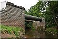
Ledwyche Brook Crossing
The Elan Valley Aqueduct crossing Ledwyche Brook.
Image: © Ian Capper
Taken: 21 Jul 2013
0.15 miles
9
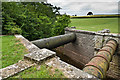
Ledwyche Brook Crossing
The Elan Valley Aqueduct crossing Ledwyche Brook.
Image: © Ian Capper
Taken: 21 Jul 2013
0.15 miles
10
Ledwyche Brook Crossing
The Elan Valley Aqueduct crossing Ledwyche Brook. Somewhat unusually for the aqueduct, this structure includes a footbridge.
Image: © Ian Capper
Taken: 21 Jul 2013
0.15 miles