IMAGES TAKEN NEAR TO
Rock Lane, LUDLOW, SY8 1ST
Introduction
This page details the photographs taken nearby to Rock Lane, SY8 1ST by members of the Geograph project.
The Geograph project started in 2005 with the aim of publishing, organising and preserving representative images for every square kilometre of Great Britain, Ireland and the Isle of Man.

There are currently over 7.5m images from over14,400 individuals and you can help contribute to the project by visiting https://www.geograph.org.uk
Image Map (Loading...)


Getting Data...Please wait
Leaflet Map data © OpenStreetMap
Images are licensed for reuse under creativecommons.org/licenses/by-sa/2.0
Notes
- Clicking on the map will re-center to the selected point.
- The higher the marker number, the further away the image location is from the centre of the postcode.
Image Listing (92 Images Found)
Images are licensed for reuse under creativecommons.org/licenses/by-sa/2.0
Image
Details
Distance
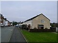
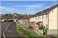
3
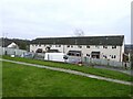
Sandpits Avenue
Housing on the 1960s Sandpits Estate.
Image: © Ian Capper
Taken: 22 May 2016
0.02 miles
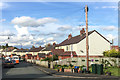
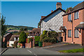
6
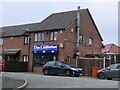
The Codfather
Fish and Chip shop on Rock Terrace. Old maps show this to be on the route of Rock Lane, a track leading from Lower Galdeford to Rock Farm, much of which has now been developed with 1960s council housing and only the lower part of which has retained the original name. An older cottage can be seen in the background.
Image: © Ian Capper
Taken: 16 Oct 2011
0.04 miles
8
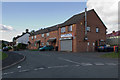
Milton Road flats
Built around 1960 as Ludlow finally started to get a grip on its appalling housing record. My first bin round was here and they always had the heaviest bins - usually coal ash was the culprit.
Image: © Richard Webb
Taken: 21 Dec 2021
0.05 miles
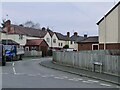
9
Milton Road
Housing on the 1960s Sandpits Estate.
Image: © Ian Capper
Taken: 22 May 2016
0.06 miles
10
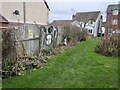
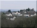
Rock Lane
Historically Rock Lane was a track leading from Lower Galdeford to Rock Farm, but only the lower part, seen here, has retained the original name, the middle part having been renamed Riddings Road and the upper part remaining as a public footpath.
In the background can be seen the Elan Valley Aqueduct Siphon Inlet House at North Farm above Whitcliffe.
Image: © Ian Capper
Taken: 4 Oct 2010
0.06 miles