IMAGES TAKEN NEAR TO
Maes Henllan, BOW STREET, SY24 5DD
Introduction
This page details the photographs taken nearby to Maes Henllan, SY24 5DD by members of the Geograph project.
The Geograph project started in 2005 with the aim of publishing, organising and preserving representative images for every square kilometre of Great Britain, Ireland and the Isle of Man.

There are currently over 7.5m images from over14,400 individuals and you can help contribute to the project by visiting https://www.geograph.org.uk
Image Map
Images are licensed for reuse under creativecommons.org/licenses/by-sa/2.0
Notes
- Clicking on the map will re-center to the selected point.
- The higher the marker number, the further away the image location is from the centre of the postcode.
Image Listing (22 Images Found)
Images are licensed for reuse under creativecommons.org/licenses/by-sa/2.0
Image
Details
Distance
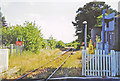
2
Llandre railway station (site), Ceredigion
Opened in 1864 as 'Llanfihangel' on the Aberystwyth & Welsh Coast Railway's line, later part of the Cambrian Railway, from Aberystwyth to Dovey Junction, Barmouth and beyond. The station was renamed 'Llandre' in 1916, and closed in 1965.
View north towards Borth, Dovey Junction etc, the image is taken from the site of the small goods yard. The station only ever had one platform. After closure, it became a private dwelling.
Image: © Nigel Thompson
Taken: 7 Jun 2017
0.11 miles
3
Near Llandre
The cemetery is just visible in the background.
Image: © N Chadwick
Taken: 18 Feb 2015
0.12 miles
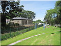
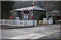
4
Site of former Llandre station
View southward, towards Aberystwyth: ex-Cambrian Railways main line - now somewhat down-at-heel, Aberystwyth - Machynlleth etc. The station (house on the right) was closed 24/6/65. (See also Image]).
Image: © Ben Brooksbank
Taken: 24 Jun 2003
0.13 miles
5
Llandre: former station, 2003
View westward, from B4353: ex-Cambrian Railway Aberystwyth (to left) - (to right) Machynlleth etc. main line. The station, but not the line - which is on the other side of the house, was closed 14/6/65 and is (obviously) now a private house. (Cf. Image]).
Image: © Ben Brooksbank
Taken: 24 Jun 2003
0.13 miles
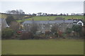
6
Converted station, Llandre
Originally called Llanfihangel (or Llanvihangel in the Anglicised spelling) after the local village of Llanfihangel Gen'eur Glyn, the name was changed to Llandre in 1916 to avoid confusion with other Llanfihangel stations. The name of the village also changed to Llandre. Such was the power of the railway!
After closure of the station (but not the railway) in 1965, it lay unused for many years, until sold and converted into a dwelling, of a rather more attractive appearance than the somewhat spartan original.
Image: © Nigel Brown
Taken: 7 Jan 2009
0.15 miles
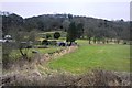
7
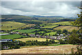
A view over Ty'n-y-parc
North of Llandre.
Image: © John Lucas
Taken: 5 Jul 2022
0.16 miles
10
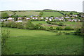
View across Llandre
The village has houses clustered along the road on each side of the valley, with the railway in between. On the far side, the houses follow the line of the B4353 to Borth.
Image: © Bill Boaden
Taken: 1 May 2011
0.19 miles