IMAGES TAKEN NEAR TO
Garth Dinas, ABERYSTWYTH, SY23 3RZ
Introduction
This page details the photographs taken nearby to Garth Dinas, SY23 3RZ by members of the Geograph project.
The Geograph project started in 2005 with the aim of publishing, organising and preserving representative images for every square kilometre of Great Britain, Ireland and the Isle of Man.

There are currently over 7.5m images from over14,400 individuals and you can help contribute to the project by visiting https://www.geograph.org.uk
Image Map
Images are licensed for reuse under creativecommons.org/licenses/by-sa/2.0
Notes
- Clicking on the map will re-center to the selected point.
- The higher the marker number, the further away the image location is from the centre of the postcode.
Image Listing (55 Images Found)
Images are licensed for reuse under creativecommons.org/licenses/by-sa/2.0
Image
Details
Distance
1
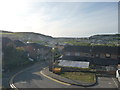
View towards Aber from part of Penparcau
This housing complex has unbeatable views towards the town.
Image: © Jeremy Bolwell
Taken: 16 May 2012
0.03 miles
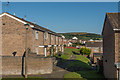
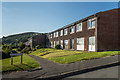
2
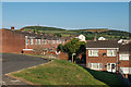
Heol Dinas
1960s/1970s housing, part of a large estate on the outskirts of Aberystwyth. In the background is Pendinas, topped by the Wellington Monument.
Image: © Ian Capper
Taken: 11 Jul 2014
0.05 miles
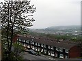
3
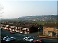
A view over Aberystwyth from Penparcau
Houses in the foreground form part of the Penparcau estate and are mainly local authority in origin. In the centre of the view is the Parc-y-llyn retail complex. In those days, the food supermarket was a Safeway store, now operated by Morrisons.
Image: © John Lucas
Taken: 24 Mar 2003
0.06 miles
4
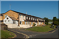
Heol Dinas
1960s/1970s housing, part of a large estate on the outskirts of Aberystwyth.
Image: © Ian Capper
Taken: 11 Jul 2014
0.07 miles
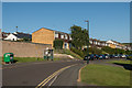
5
Heol Tyn-y-Fron
1960s/1970s housing, part of a large estate on the outskirts of Aberystwyth.
Image: © Ian Capper
Taken: 11 Jul 2014
0.09 miles
6
Penparcau
A view over the mostly ex-local authority housing estate at Penparcau, as seen from Garth Dinas.
Image: © John Lucas
Taken: 9 May 2004
0.10 miles
7
Heol Tyn-y-Fron
1960s/1970s housing, part of a large estate on the outskirts of Aberystwyth.
Image: © Ian Capper
Taken: 11 Jul 2014
0.13 miles
8
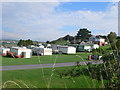
Midfield Holiday Park
At Southgate near Aberystwyth.
Image: © Eirian Evans
Taken: 8 Oct 2010
0.14 miles
9
Ystwyth Close
1960s/1970s housing, part of a large estate on the outskirts of Aberystwyth.
Image: © Ian Capper
Taken: 11 Jul 2014
0.15 miles
10
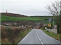
The A4120 approaching Aberystwyth
The last straight bit, before a sudden descent and wiggle before its junctions with the B4340 and A487. Beyond, Aberystwyth's iconic Wellington monument can be seen on top of Pen Dinas, with the ramparts of the hill top fort also clearly visible.
Image: © Nigel Brown
Taken: 8 Dec 2009
0.15 miles