IMAGES TAKEN NEAR TO
Goginan, ABERYSTWYTH, SY23 3PB
Introduction
This page details the photographs taken nearby to SY23 3PB by members of the Geograph project.
The Geograph project started in 2005 with the aim of publishing, organising and preserving representative images for every square kilometre of Great Britain, Ireland and the Isle of Man.

There are currently over 7.5m images from over14,400 individuals and you can help contribute to the project by visiting https://www.geograph.org.uk
Image Map
Images are licensed for reuse under creativecommons.org/licenses/by-sa/2.0
Notes
- Clicking on the map will re-center to the selected point.
- The higher the marker number, the further away the image location is from the centre of the postcode.
Image Listing (14 Images Found)
Images are licensed for reuse under creativecommons.org/licenses/by-sa/2.0
Image
Details
Distance
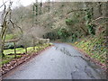
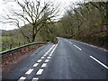
1
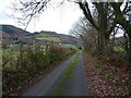
The lower lane in Dollwen, Christmas Day 2018
More or less the same place as Image, but looking in the opposite direction along the lane. Dogs need to be walked, even on Christmas Day.
Image: © Richard Law
Taken: 25 Dec 2018
0.09 miles
2
Up the lane towards Coed Penbryn
A view from the southern side of Dollwen village, towards the hillside carrying the A44 Aberystwyth to Llangurig road.
Image: © Richard Law
Taken: 25 Dec 2018
0.11 miles
4
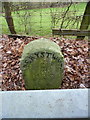
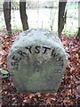
19th Century turnpike milestone - Goginan
Grade II listed https://britishlistedbuildings.co.uk/300082810-milestone-sw-of-goginan-melindwr#.XExxzlz7TIU in 2004, the milestone stands immediately behind the modern 'Armco' barrier, and presumably dates from the turnpiking of the road in 1812. This is one of a series along the A44.
Image: © Richard Law
Taken: 25 Dec 2018
0.18 miles
5
Old Milestone by the A44, southwest of Goginan, Melindwr parish
Aberystwyth tombstone by the A44, in parish of Melindwr (Ceredigion District), Southwest of Goginan, behind crash barrier.
Inscription reads:-
ABERYSTWYTH
7
MILES
Grade II listed by Cadw.
Reference Number: 82810 https://cadwpublic-api.azurewebsites.net/reports/listedbuilding/FullReport?lang=&id=82810
Surveyed
Milestone Society National ID: CRD_AYLG07
Image: © Milestone Society
Taken: Unknown
0.18 miles
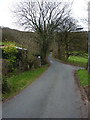
6
The lower lane in Dollwen
Goginan is a hamlet on the A44 road in the valley of the Afon Melindwr - most visitors pass at 40mph on the main road, maybe stopping atImage for a pint on the way through. Dollwen lies 150' below it in the valley; a collection of houses and cottages, plus two currently derelict old chapels.
Image: © Richard Law
Taken: 25 Dec 2017
0.19 miles
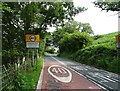
7
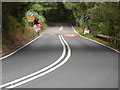
Goginan A44
The A44 coming out of Goginan, towards Aberystwyth. A bad example of information overload in terms of road signs!
Image: © Richard Lewis
Taken: 18 Jul 2018
0.21 miles
8
Sharp left on the narrow lane down to Dollwen
Image: © Richard Law
Taken: 25 Dec 2018
0.22 miles
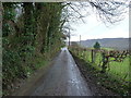
9
Junction of a lane off the A44
The main road carries on uphill through Goginan, the lane drops to Dollwen and the valley of the Afon Melindwr.
Image: © Richard Law
Taken: 25 Dec 2018
0.22 miles
10
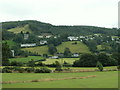
Goginan and Dollwen
The village of Goginan on the A44. Looking S, the A44 runs along the top line of houses.
Image: © Nigel Callaghan
Taken: 11 Aug 2005
0.22 miles