IMAGES TAKEN NEAR TO
Garth Owen, NEWTOWN, SY16 1JN
Introduction
This page details the photographs taken nearby to Garth Owen, SY16 1JN by members of the Geograph project.
The Geograph project started in 2005 with the aim of publishing, organising and preserving representative images for every square kilometre of Great Britain, Ireland and the Isle of Man.

There are currently over 7.5m images from over14,400 individuals and you can help contribute to the project by visiting https://www.geograph.org.uk
Image Map
Images are licensed for reuse under creativecommons.org/licenses/by-sa/2.0
Notes
- Clicking on the map will re-center to the selected point.
- The higher the marker number, the further away the image location is from the centre of the postcode.
Image Listing (57 Images Found)
Images are licensed for reuse under creativecommons.org/licenses/by-sa/2.0
Image
Details
Distance
1
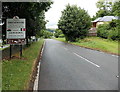
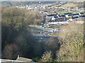
Southern boundary of Newtown, Powys
The A483 Dolfor Road passes the boundary sign at the southern edge of Newtown, the largest town in Powys. Its population was 12,783 on the day of the 2001 Census.
The sign states that Newtown has been a new town since 1279. It is twinned with Les Herbiers (France).
Image: © Jaggery
Taken: 4 Aug 2013
0.05 miles
2
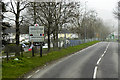
Entering Newtown
Welcome sign on Dolfor Road (A483) on the southern outskirts of Newtown.
Image: © David Dixon
Taken: 15 Apr 2016
0.05 miles
3
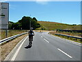
Riding up Dolfor Road
Approaching the intersection with the feeder roads on/off the new Newtown bypass, at the start of a hot afternoon on the hills to the south of the town.
Image: © Richard Law
Taken: 9 Jul 2022
0.05 miles
4

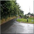
Heol Ashley extension, Mochdre Estate
Heading for the new roundabout on A483 Dolfor Road.
The houses up on the right are on Upper Dolfor Road.
Image: © Penny Mayes
Taken: 6 Jan 2019
0.07 miles
5
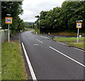
Upper Dolfor Road, Newtown
At the southern edge of Newtown, Upper Dolfor Road diverges from the A483 Dolfor Road. The circular sign with a red edge shows that vehicles weighing more than 7.5 tonnes are prohibited, except for access.
Image: © Jaggery
Taken: 4 Aug 2013
0.08 miles
6
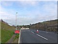
New roundabout on A483 for Mochdre Estate road
Heol Ashley, the spine road through the Mochdre Estate, is being extended to link to the A483 here.
Taken from Upper Dolfor Road.
Image: © Penny Mayes
Taken: 6 Jan 2019
0.08 miles
7
Start of the 30 zone and pavements in Newtown
Viewed along the A483 Dolfor Road. Upper Dolfor Road joins from the right.
The end of the grass verge and the start of pavements at the southern edge of Newtown
coincides with the reduction in the speed limit from the National Speed Limit to 30mph.
Image: © Jaggery
Taken: 4 Aug 2013
0.09 miles
8

Garthowen Shops, Plantation Lane, Newtown, Powys
The shops at Garthowen, Newtown, Powys
Image: © Henry Spooner
Taken: 27 May 2009
0.12 miles
9
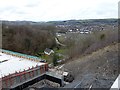
A483 Dolfor Road
Seen from the Upper Dolfor Road bridge.
The route will be changed with the construction of the bypass and a roundabout is planned in that area.
Image: © Penny Mayes
Taken: 1 Apr 2018
0.13 miles
10
Heol Ashley extension, Mochdre Estate
Heading for the new roundabout on A483 Dolfor Road.
Image: © Penny Mayes
Taken: 6 Jan 2019
0.14 miles