IMAGES TAKEN NEAR TO
Twemlows, Higher Heath, WHITCHURCH, SY13 2HB
Introduction
This page details the photographs taken nearby to SY13 2HB by members of the Geograph project.
The Geograph project started in 2005 with the aim of publishing, organising and preserving representative images for every square kilometre of Great Britain, Ireland and the Isle of Man.

There are currently over 7.5m images from over14,400 individuals and you can help contribute to the project by visiting https://www.geograph.org.uk
Image Map
Images are licensed for reuse under creativecommons.org/licenses/by-sa/2.0
Notes
- Clicking on the map will re-center to the selected point.
- The higher the marker number, the further away the image location is from the centre of the postcode.
Image Listing (11 Images Found)
Images are licensed for reuse under creativecommons.org/licenses/by-sa/2.0
Image
Details
Distance
1
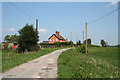
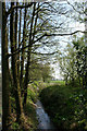
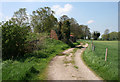
Twemlows Cottages
One of a pair of farm cottages at the top of a slight rise on the track to The Twemlows
Image: © Espresso Addict
Taken: 6 May 2008
0.03 miles
2
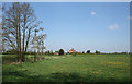
View towards Twemlows Cottages
A pair of farm cottages stand on a slight rise on the track to The Twemlows (just visible in distance). View from the farm track running south east (not right of way)
Image: © Espresso Addict
Taken: 6 May 2008
0.11 miles
3
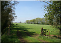
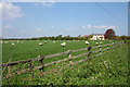
Pasture by Twemlows Big Wood
Small pasture fields beside Twemlows Big Wood (left). An unnamed stream is hidden in the trees on the left, and one of its many tributaries runs by the line of willows (right). Vehicles on the A41 are visible in the middle distance, and the building on the horizon is on the A49. View from the junction of the track to The Twemlows with the public footpath running south
Image: © Espresso Addict
Taken: 6 May 2008
0.11 miles
4
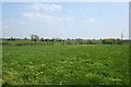
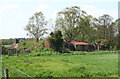
Pasture south of The Twemlows
South of The Twemlows the predominant agricultural usage is cattle and sheep pasture. The double fence (left and centre) hides a small stream. View from the track to The Twemlows, north east of Twemlows Cottages
Image: © Espresso Addict
Taken: 6 May 2008
0.12 miles
5
Sheep pasture and The Twemlows
Sheep pasture south of the large farm of The Twemlows (right; in Image). View from the track to The Twemlows
Image: © Espresso Addict
Taken: 6 May 2008
0.12 miles
6
Stream on the edge of Twemlows Big Wood
An unnamed stream forms the north and east boundaries of Twemlows Big Wood. The field that cuts into the woodland is just visible (right). View from the track to The Twemlows at the junction with a public footpath running south. For another view, see: Image
Image: © Espresso Addict
Taken: 6 May 2008
0.12 miles
7
Derelict building by farm track: close up
One of a group of derelict buildings by a farm track running south east (not a right of way). The area had several military uses over the 20th century, but the buildings were probably accommodation associated with the use of Prees Common as an airfield during the Second World War. For a view of this building in context, see: Image
Image: © Espresso Addict
Taken: 6 May 2008
0.16 miles
8
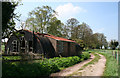
Derelict buildings by farm track
Another view of some of a group of derelict buildings by a farm track running south east (not a right of way). The area had several military uses over the 20th century, but the buildings were probably accommodation associated with the use of Prees Common as an airfield during the Second World War. For a close up of the central of these buildings, see: Image Twemlows Big Wood is visible in the distance
Image: © Espresso Addict
Taken: 6 May 2008
0.16 miles
9
Derelict buildings by farm track
Another view of two of the group of derelict buildings by a farm track running south east (not a right of way). For a close up of the right-hand building, see: Image
Image: © Espresso Addict
Taken: 6 May 2008
0.16 miles
10
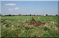
Remains of derelict building near Twemlows Cottages
Little is left of several of the group of derelict airfield buildings except the concrete foundations. Twemlows Cottages (left) and The Twemlows (right; in Image) are visible in the distance
Image: © Espresso Addict
Taken: 6 May 2008
0.17 miles