IMAGES TAKEN NEAR TO
Wyle Cop, SHREWSBURY, SY1 1XE
Introduction
This page details the photographs taken nearby to Wyle Cop, SY1 1XE by members of the Geograph project.
The Geograph project started in 2005 with the aim of publishing, organising and preserving representative images for every square kilometre of Great Britain, Ireland and the Isle of Man.

There are currently over 7.5m images from over14,400 individuals and you can help contribute to the project by visiting https://www.geograph.org.uk
Image Map
Images are licensed for reuse under creativecommons.org/licenses/by-sa/2.0
Notes
- Clicking on the map will re-center to the selected point.
- The higher the marker number, the further away the image location is from the centre of the postcode.
Image Listing (1690 Images Found)
Images are licensed for reuse under creativecommons.org/licenses/by-sa/2.0
Image
Details
Distance
1
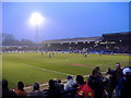
Gay Meadow, Shrewsbury
Final season at Gay Meadow, historic riverside football ground. View from Wakeman End. Shrewsbury Town 3, Rochdale 0.
Image: © Peter Evans
Taken: 27 Mar 2007
0.02 miles
2
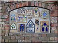
Ceramic mural near the English Bridge, Shrewsbury
By the riverside path
Image: © David Smith
Taken: 23 Apr 2015
0.03 miles
3
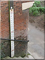
Flood marker by the English Bridge
The marker is adjacent to the steps leading down from the English Bridge to the footpath on the left bank of the Severn. The range shown is 49.7 to 52.0, which is presumably metres above Ordnance Datum (the map shows the 50m contour close to the river).
Image: © Stephen Craven
Taken: 20 Nov 2008
0.03 miles
4
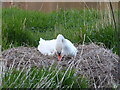
Swan nest in Shrewsbury
She diligently fusses with the nest materials, making it higher and more shaped to her body.
Image: © Jeremy Bolwell
Taken: 4 Apr 2021
0.03 miles
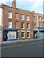
5
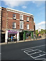
43 & 44 Wyle Cop, Shrewsbury
Very similar in style and history to the neighbouring Image, this pair of early 18th century houses with later shop fronts was also Grade II listed https://britishlistedbuildings.co.uk/101255117-43-and-44-wyle-cop-shrewsbury#.XATigGj7RPY in 1953.
Image: © Richard Law
Taken: 19 Oct 2018
0.03 miles
6
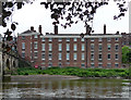
Severn Court, Wyle Cop, Shrewsbury
Early C19th terrace next to the English Bridge (Image]), the bridge end curved to accommodate a flight of steps. Grade II listed.
Now known as English Bridge Court.
Image: © Stephen Richards
Taken: 16 May 2014
0.03 miles
7
40, 41 & 42 Wyle Cop, Shrewsbury
The houses are probably 18th century in origin, but rather disguised by an early 20th century refacing in brick; they were collectively Grade II listed https://britishlistedbuildings.co.uk/101270455-40-41-and-42-wyle-cop-shrewsbury#.XAThXGj7RPY in 1953.
Image: © Richard Law
Taken: 19 Oct 2018
0.03 miles
8
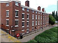
English Bridge Court, Shrewsbury
Housing on the west bank of the River Severn, on the corner of Wyle Cop, viewed from English Bridge. http://www.geograph.org.uk/photo/4004904
Image: © Jaggery
Taken: 31 May 2014
0.03 miles
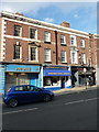
9
37, 38 & 39 Wyle Cop, Shrewsbury
A 3-house range, built around the middle of the 18th century, but suspected to have an earlier (medieval?) core; they were collectively Grade II listed https://britishlistedbuildings.co.uk/101255116-37-38-and-39-wyle-cop-shrewsbury#.XATgGGj7RPY in 1972. The shopfront on the left is clearly a relatively recent addition.
Image: © Richard Law
Taken: 19 Oct 2018
0.03 miles
10
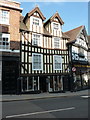
27 Wyle Cop, Shrewsbury
Probably late 16th century, and Grade II listed https://britishlistedbuildings.co.uk/101254949-27-wyle-cop-shrewsbury#.XAOnv9SLTGg in 1953. This structure was originally built as a rather fine town house, and has latterly been converted, at least on the ground floor, to retail premises, and has been part of the Tanners Wine merchants for some years.
Image: © Richard Law
Taken: 19 Oct 2018
0.04 miles