IMAGES TAKEN NEAR TO
Dolgoch, OSWESTRY, SY10 8LN
Introduction
This page details the photographs taken nearby to Dolgoch, SY10 8LN by members of the Geograph project.
The Geograph project started in 2005 with the aim of publishing, organising and preserving representative images for every square kilometre of Great Britain, Ireland and the Isle of Man.

There are currently over 7.5m images from over14,400 individuals and you can help contribute to the project by visiting https://www.geograph.org.uk
Image Map
Images are licensed for reuse under creativecommons.org/licenses/by-sa/2.0
Notes
- Clicking on the map will re-center to the selected point.
- The higher the marker number, the further away the image location is from the centre of the postcode.
Image Listing (8 Images Found)
Images are licensed for reuse under creativecommons.org/licenses/by-sa/2.0
Image
Details
Distance
1
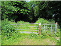
Entrance gate to nature reserve near Llynclys
This leads to Dolgoch Quarry Nature Reserve, on the site of an abandoned limestone quarry.
Image: © David Weston
Taken: 5 Jul 2013
0.08 miles

3
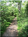
Path through the trees
On the northern side of Llynclys Hill.
Image: © John H Darch
Taken: 8 May 2020
0.13 miles
4
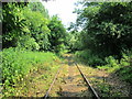
Disused railway line near Llynclys
The line was 'mothballed' in 1998; from about 100 yards west of this photo (behind the camera), the rails have been removed. This was a branch of the Cambrian Railway to the quarries at Porthywaen. West of the original end, it was extended to Llangynog, following the valley of the Afon Tanat, as the Tanant Light Railway in the early 20th Century. The line was closed West of Blodwell during the 1950s.
More information of the history of this line can be found at http://www.cambrianrailways.com/html/history.html , together with information on the active restoration of the Cambrian railway line from Oswestry southwards.
Image: © David Weston
Taken: 5 Jul 2013
0.14 miles
5
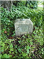
Oswestry FBM
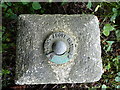
This rectangular block comprises the visible part of the Oswestry Fundamental Benchmark. In effect, it is the protective cap to a chamber excavated below ground level, containing a bolt affixed to a piece of 'immovable' bedrock, and it is that bolt to which the stated height of 352.831 feet (107.5429m) above sea level actually refers.
Image: © Richard Law
Taken: 19 Jul 2016
0.18 miles
6
Height plate - Oswestry FBM
The brass bolt and datum height plate on the surface of the Oswestry Fundamental, which is a precise record of altitude above Newlyn Sea Level Datum.
Image: © Richard Law
Taken: 19 Jul 2016
0.18 miles
8
Along the A495 north of Llynclys Hill
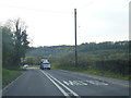
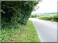
One of the main roads into (or out of) Mid Wales. This particular route winds its way through some rather lovely countryside between Llynclys crossroads and Llanfair Caereinion. The concrete block in the bottom of the hedge, lower left, is the Oswestry Fundamental Benchmark, one of 190 high-accuracy height markers across the country, of which this one is levelled at 352 feet and 10 inches above Newlyn Datum.
Image: © Richard Law
Taken: 19 Jul 2016
0.22 miles