IMAGES TAKEN NEAR TO
Kinnerley, OSWESTRY, SY10 8EG
Introduction
This page details the photographs taken nearby to SY10 8EG by members of the Geograph project.
The Geograph project started in 2005 with the aim of publishing, organising and preserving representative images for every square kilometre of Great Britain, Ireland and the Isle of Man.

There are currently over 7.5m images from over14,400 individuals and you can help contribute to the project by visiting https://www.geograph.org.uk
Image Map
Images are licensed for reuse under creativecommons.org/licenses/by-sa/2.0
Notes
- Clicking on the map will re-center to the selected point.
- The higher the marker number, the further away the image location is from the centre of the postcode.
Image Listing (19 Images Found)
Images are licensed for reuse under creativecommons.org/licenses/by-sa/2.0
Image
Details
Distance
2
Rails once ran - Edgerley, Shropshire
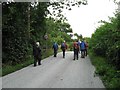
Looking eastwards from the bridge in Edgerley 1, the long-abandoned former route of the Shropshire & Montgomeryshire Railway - nicknamed the Potts - can be seen. Passing through the gate which is seen ahead in the centre of the picture, the line ran through the present Nesscliffe Military Training Area - no public access - to the station house, a rebuilt one, at Shrawardine (locally pronounced Shraden). There are a number of books available which give a history of this former line. Time taken 3.08 pm BST (British Summer Time). Image Image
Image: © Martin Richard Phelan
Taken: 17 Aug 2013
0.06 miles
3
The road to Kynaston - Edgerley, Shropshire
Just to the west of here, behind the photographer, lies the site of Kinnerley Junction where the Shropshire & Montgomeryshire Railway, the 'Potts', diverged, one branch turning southwards to Criggion and the other westwards to Llanymynech. In existence from 1866 to 1962, the line had a very chequered history and there are a number of books published on the story of it. The trackbed these days is private land, with no public access. Time taken 3.13 pm BST (British Summer Time).
Image Image
Image: © Martin Richard Phelan
Taken: 17 Aug 2013
0.06 miles
4
A bridge there was - Edgerley, Shropshire
The embankment ahead in this picture was the filled-in road bridgehole over the Shropshire & Montgomeryshire Railway at Edgerley. This line was intended to make a link between The Potteries at Stoke on Trent and Dublin, hence it's nickname the Potts, but this plan never came to fruition. Somewhat confusingly, there are two places named Edgerley on the OS map here, but whether they are separate or the same place named twice is not clear. Time taken 3.02 pm BST (British Summer Time).
Image Image
Image: © Martin Richard Phelan
Taken: 17 Aug 2013
0.07 miles
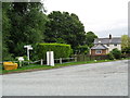
5
Bridge over Kinnerley Junction - Edgerley, Shropshire
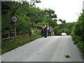
Some of the group of Railway Ramblers at Edgerley stopping for a look from the bridge at the site of Kinnerley Junction, from where a 5-mile branch left the Shropshire and Montgomeryshire Railway for the basalt quarry at Criggion Image The sign on the left shows a 22 ton weight limit on the bridge. Time taken 3.07 pm BST (British Summer Time).
Image: © Martin Richard Phelan
Taken: 17 Aug 2013
0.07 miles
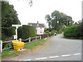
8
Towards Kinnerley Junction - Edgerley, Shropshire
A party of Railway Ramblers at Edgerley on the B-road between Pentre and Kinnerley as they approach the road bridge overlooking the site of Kinnerley Junction. The now-vanished Shropshire and Montgomeryshire Railway once ran this way and at Kinnerley Junction a 5-mile branch led off to the basalt quarry at Criggion Image Time taken 3.07 pm BST (British Summer Time).
Image: © Martin Richard Phelan
Taken: 17 Aug 2013
0.09 miles
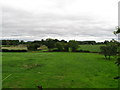
9
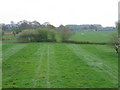
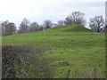
Course of the Shropshire & Montgomery Railway
Looking over Image along the course of the Shropshire and Montgomery Railway which ran directly away from the photographer towards the trees. The line finally closed in 1962 after a chaotic history and was dismantled. From the lines in the field it looks like a ghost of the tracks still survives!
Image: © David Stowell
Taken: 28 Apr 2006
0.09 miles
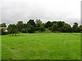
10
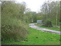
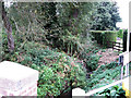
Site of Kinnerley Junction
Looking west from the approach to Image The farm track swings onto the former railway alignment at the site of the former junction station and main workshops of the Shropshire and Montgomery Railway.
Image: © David Stowell
Taken: 28 Apr 2006
0.09 miles