
IMAGES TAKEN NEAR TO
Moorland Road, LONDON, SW9 8UA
Introduction
This page details the photographs taken nearby to Moorland Road, SW9 8UA by members of the Geograph project.
The Geograph project started in 2005 with the aim of publishing, organising and preserving representative images for every square kilometre of Great Britain, Ireland and the Isle of Man.

There are currently over 7.5m images from over14,400 individuals and you can help contribute to the project by visiting https://www.geograph.org.uk
Image Map
Images are licensed for reuse under creativecommons.org/licenses/by-sa/2.0
Notes
- Clicking on the map will re-center to the selected point.
- The higher the marker number, the further away the image location is from the centre of the postcode.
Image Listing (48 Images Found)
Images are licensed for reuse under creativecommons.org/licenses/by-sa/2.0
Image
Details
Distance
1
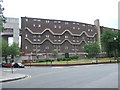
"Barrier Block", Brixton
Southwyck House, a block of flats in South London, is also known locally as "Barrier Block". The block was built in around 1970, at a time when there were plans for a 6-lane elevated motorway to pass in front of the building. The block was designed to bounce traffic noise back, and to protect residents from fumes. The motorway formed part of the "London Ringways" plan, which would have seen motorways built in 4 concentric circles around London. The overall plan was abandoned, although some stretches of motorway have been built.
Image: © Malc McDonald
Taken: 30 May 2011
0.06 miles
2
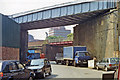
Site of former East Brixton station, 1991
View northward on Gresham Road, under the ex-LB&SC South London line (Victoria, (to left) - (to right) Peckham Rye - London Bridge) on which East Brixton station was situated (on the right) until closed 5/1/76. Beyond is the ex-SE&CR Victoria - Chatham - Ramsgate/Dover main line through Brixton station off to the left. (Cf. Image]).
Image: © Ben Brooksbank
Taken: 5 Jun 1991
0.08 miles
3
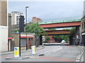
Gresham Road, Brixton
Two railway lines cross Gresham Road in Brixton, South London. The lines run more-or-less parallel from Peckham Rye for around 5 miles to London's Victoria terminus station. Suburban services operated by Southern generally use the higher bridge, although these services will cease in 2012. London Overground trains will by then be using the route. Suburban and longer-distance services to the Kent Coast operated by Southeastern generally use the bridge further back.
Image: © Malc McDonald
Taken: 30 May 2011
0.10 miles
4
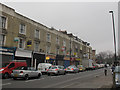
Shops on Coldharbour Lane, Brixton
Despite this being around midday on a weekday, many of the shop units were closed.
Image: © Stephen Craven
Taken: 19 Mar 2015
0.11 miles
5
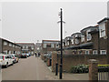
Corry Drive, Brixton (2)
The eastern arm of the road. See also Image
Corry Drive is roughly on the alignment of the former Sussex Road, part of the “Lambeth Wick” estate taken from Lord Holland’s estate in the mid 19th century. The area was completely redeveloped in the 1970s.
Image: © Stephen Craven
Taken: 19 Mar 2015
0.11 miles
6
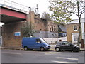
East Brixton railway station (site), London
Opened in 1866 as 'Loughborough Park' by the London Brighton & South Coast Railway on the line from Brixton to Denmark Hill, this station received its last name in 1894. It closed in 1976.
View north east on Barrington Road at the former entrance. The wooden platforms used to overhang the side of the viaduct and were demolished soon after closure.
Image: © Nigel Thompson
Taken: 13 Nov 2014
0.12 miles
7
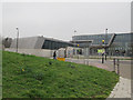
Evelyn Grace Academy, Loughborough Park (1)
This academy building opened in 2010. The school is part of the ARK network of academy schools. The main building is about 125m long so it took two photos to cover it. See Image and also Image for a view from the other side.
Image: © Stephen Craven
Taken: 19 Mar 2015
0.12 miles
8
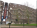
Southwyck House, Brixton (1)
Southwyck House, also known locally as the "barrier block", consists of five linked high-rise blocks built c.1980 and forming a long row on the south side of Coldharbour Lane. The name may reflect the former name of the area, “Lambeth Wick”. This photos only shows part of it. See also Image for a view from the other side.
For a more detailed history and description, see http://www.urban75.org/brixton/features/barrier.html
Image: © Stephen Craven
Taken: 19 Mar 2015
0.13 miles
9
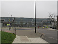
Evelyn Grace Academy, Loughborough Park (2)
This academy building opened in 2010. The school is part of the ARK network of academy schools. The main building is about 125m long so it took two photos to cover it. See Image and also Image for a view from the other side.
Image: © Stephen Craven
Taken: 19 Mar 2015
0.13 miles
10
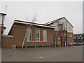
Moorlands Community Centre, Brixton
The modern community centre occupies roughly the site of the long-vanished Sussex Road Mission Hall (part of the Anglican parish of St John, Angell Town). It was still in use as of 1961 according to a document on the Diocesan file, but demolished when the area was redeveloped in the 1970s.
Sussex Road was roughly on the alignment of the present Corry Drive Image, and existed, with terraced houses, by the time of the 1861 census, according to genealogy websites. It was part of the “Lambeth Wick” estate taken from Lord Holland’s estate.
Image: © Stephen Craven
Taken: 19 Mar 2015
0.14 miles