IMAGES TAKEN NEAR TO
New Kings Road, LONDON, SW6 4XE
Introduction
This page details the photographs taken nearby to New Kings Road, SW6 4XE by members of the Geograph project.
The Geograph project started in 2005 with the aim of publishing, organising and preserving representative images for every square kilometre of Great Britain, Ireland and the Isle of Man.

There are currently over 7.5m images from over14,400 individuals and you can help contribute to the project by visiting https://www.geograph.org.uk
Image Map
Images are licensed for reuse under creativecommons.org/licenses/by-sa/2.0
Notes
- Clicking on the map will re-center to the selected point.
- The higher the marker number, the further away the image location is from the centre of the postcode.
Image Listing (241 Images Found)
Images are licensed for reuse under creativecommons.org/licenses/by-sa/2.0
Image
Details
Distance
1

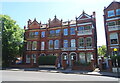
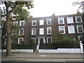
Peterborough Road, London SW6
View north over Peterborough Road towards Parsons Green [trees in the background]. The 'Duke on The Green' public house is at the end of the road on the left [previously known as 'The Duke of Cumberland'] - Evening Standard Pub of the Year 1971.
Image: © Paul Leonard
Taken: 14 May 2008
0.00 miles
4
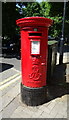
Edward VII postbox on New King's Road
Postbox No. SW6 15.
Image: © JThomas
Taken: 27 May 2022
0.04 miles
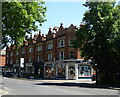
5
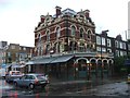
Parsons Green
It's the name of the road and the green to the left. It's New King's Road either side of it.
Image: © David Howard
Taken: 16 Mar 2014
0.04 miles
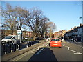
6
Houses overlooking Parsons Green
On New King's Road
Image: © David Howard
Taken: 25 Sep 2016
0.05 miles
7
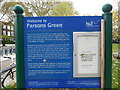
Information Board at Parsons Green
Situated off the A308 New King's Road SW6 4XG, this information board has the following wording:
Welcome to
Parsons Green
The name is derived from the parsonage or rectory that
used to stand midway along the western side of the
Green. The rectory was demolished in 1882, and St.Dionis
Church built on the site. The Green was formerly a portion
of the Manor of Fulham.
References to Parsons Green date back to at least the 14th
century. A pond known in the 17th century as Colepitts
was situated at the south east corner of the Green. It was
filled in during the 19th century when the natural spring
by which it as fed was destroyed during the construction
of the main drainage of King's (later New King's) Road. In
1878 a granite drinking fountain was erected by the Rev.
R.G.Baker on the south side of the Green facing New King's
Road.
Parson's Green, together with Eelbrook Common and Brook
Green, was purchased by the Metropolitan Board of Works
for £5,000 in 1881 and administered as a public open space.
The administration and maintenance of Parsons Green was
transferred to the London Borough of Hammersmith in
April 1971.
Good users guide to parks
. Please be aware of other park users and be considerate. Formal byelaws apply
to this site.
. Keep your park tidy and use bins provided.
. We welcome responsible dog owners. Please dispose of dog mess in the bins
provided.
This park is in a Dog Control Zone.
The notice in the holder on the right says:
PUBLIC NOTICE
BARBEQUING IS NOT ALLOWED IN THIS PARK
At the bottom right of the board is the wording:
This site is managed by Hammersmith & Fulham Council and patrolled by the
Parks Constabulary.
Image: © David Hillas
Taken: 29 Oct 2019
0.05 miles
9
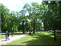
Parsons Green Park
Parsons Green Park is the former village green. It was where the Vicar of Fulham used to live and hence 'The Parson's Green'. More about Parsons Green can be seen at https://www.ianvisits.co.uk/articles/londons-pocket-parks-parsons-green-sw6-58148/?utm_source=newsletter&utm_medium=email
Image: © Marathon
Taken: 8 Jun 2011
0.06 miles
10
Putney Bridge to Parsons Green and back via Hurlingham (82)
Pedestrian in Parson's Green
Image: © Basher Eyre
Taken: 26 Mar 2011
0.06 miles