IMAGES TAKEN NEAR TO
Abbeville Road, LONDON, SW4 9LU
Introduction
This page details the photographs taken nearby to Abbeville Road, SW4 9LU by members of the Geograph project.
The Geograph project started in 2005 with the aim of publishing, organising and preserving representative images for every square kilometre of Great Britain, Ireland and the Isle of Man.

There are currently over 7.5m images from over14,400 individuals and you can help contribute to the project by visiting https://www.geograph.org.uk
Image Map
Images are licensed for reuse under creativecommons.org/licenses/by-sa/2.0
Notes
- Clicking on the map will re-center to the selected point.
- The higher the marker number, the further away the image location is from the centre of the postcode.
Image Listing (118 Images Found)
Images are licensed for reuse under creativecommons.org/licenses/by-sa/2.0
Image
Details
Distance
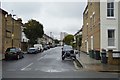
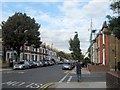
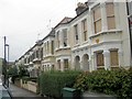
3
Terraced houses in Abbeville Road, Clapham
A row of houses with decorated porches and window surrounds; part of the development of Clapham at the end of the 19th century
Image: © David Smith
Taken: 28 Nov 2013
0.04 miles
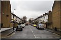
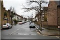
4
Abbeville Road, Clapham
Terraced houses in this residential road. The roofs above the bay windows are interesting. Presumably, this style of construction, with a steep roof above the projecting window bays, means that there is no junction of tiles in a gable.
Image: © David Smith
Taken: 28 Nov 2013
0.06 miles
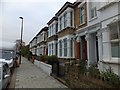
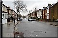
5
Victorian houses in Abbeville Road
Abbeville Road is part of the grid of streets that form the late-Victorian Clapham Park development (http://en.wikipedia.org/wiki/Clapham_Park ), which catered for the first Tube commuters.
Image: © Chris Reynolds
Taken: 29 Sep 2009
0.07 miles
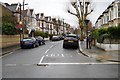
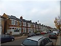
10
A Victorian Terrace in Franconia Road, Clapham
Franconia Road is a typical late-Victorian, middle-class terrace development within the grid of streets around Abbeville Road. The area developed rapidly as the spread of railways and the Tube in the area made commuting practical. The area, known as Clapham Park (http://en.wikipedia.org/wiki/Clapham_Park ), is also sometimes referred to as Abbeville Village.
Image: © Chris Reynolds
Taken: 15 Sep 2009
0.09 miles