IMAGES TAKEN NEAR TO
Thornton Avenue, LONDON, SW2 4HH
Introduction
This page details the photographs taken nearby to Thornton Avenue, SW2 4HH by members of the Geograph project.
The Geograph project started in 2005 with the aim of publishing, organising and preserving representative images for every square kilometre of Great Britain, Ireland and the Isle of Man.

There are currently over 7.5m images from over14,400 individuals and you can help contribute to the project by visiting https://www.geograph.org.uk
Image Map
Images are licensed for reuse under creativecommons.org/licenses/by-sa/2.0
Notes
- Clicking on the map will re-center to the selected point.
- The higher the marker number, the further away the image location is from the centre of the postcode.
Image Listing (64 Images Found)
Images are licensed for reuse under creativecommons.org/licenses/by-sa/2.0
Image
Details
Distance
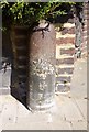
1
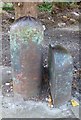
Old Boundary Marker by the B221, New Park Road, Streatham
Parish Boundary Marker by the B221, in parish of Streatham (Lambeth District), New Park Road at junction with Thornton Avenue SW2, against garden boundary fence next to Boundary Marker: SY_STRE01pb Image
Inscription reads:-
1877
Surveyed
Milestone Society National ID: SY_CLAP02pb
Image: © Milestone Society
Taken: Unknown
0.01 miles
2
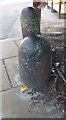
Old Boundary Marker by the B221, New Park Road, Streatham
Parish Boundary Marker by the B221, in parish of Streatham (Lambeth District), New Park Road at junction with Thornton Avenue SW2, against garden boundary fence next to Boundary Marker: SY_CLAP02pb Image
Surveyed
Milestone Society National ID: SY_STRE01pb
Image: © Milestone Society
Taken: Unknown
0.02 miles
3
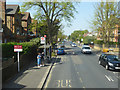
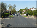
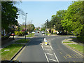
Thornton Avenue, SW2 (B221)
The bus stop ahead is New Park Road, towards Balham or Clapham Common.
Image: © Robin Webster
Taken: 19 Apr 2019
0.02 miles
4
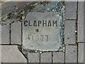
Old Boundary Marker on Emmanuel Road, London SW12
Parish Boundary Marker set in the pavement on the northwest side of the junction of Emmanuel Road and the B221 Thornton Road, both SW12. On the former boundary of Clapham and Streatham parishes, now Lambeth Borough.
Milestone Society National ID: SY_CLAP13pb
Image: © R Heywood
Taken: 5 Sep 2021
0.03 miles
5
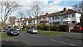
Suburban housing at the southern end of New Park Road
Image: © David Martin
Taken: 27 Mar 2015
0.03 miles
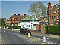
7
Thornton Road, SW12 (B221)
The foreground crossroads has New Park Road right and Emmanuel Road left.
Image: © Robin Webster
Taken: 19 Apr 2019
0.05 miles
8
Old Boundary Marker by Emmanuel Road, Streatham Parish
Parish Boundary Marker by the UC road, in parish of Streatham (Lambeth District), Emmanuel Road SW2, in front of No 80 against wall, opposite Salford Road.
Surveyed
Milestone Society National ID: SY_CLAP03pb.
Image: © Milestone Society
Taken: Unknown
0.09 miles
9
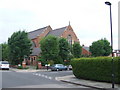
St. Thomas's Church, near Streatham Hill
St. Thomas's Church on Telford Avenue, near Streatham Hill in South London.
Image: © Malc McDonald
Taken: 30 May 2011
0.09 miles
10
Thornton Road, SW12
Used by the B221 as far as here, where it sweeps round to the right onto Kings Avenue.
Image: © Robin Webster
Taken: 19 Apr 2019
0.10 miles