IMAGES TAKEN NEAR TO
Christchurch Road, LONDON, SW19 2FA
Introduction
This page details the photographs taken nearby to Christchurch Road, SW19 2FA by members of the Geograph project.
The Geograph project started in 2005 with the aim of publishing, organising and preserving representative images for every square kilometre of Great Britain, Ireland and the Isle of Man.

There are currently over 7.5m images from over14,400 individuals and you can help contribute to the project by visiting https://www.geograph.org.uk
Image Map
Images are licensed for reuse under creativecommons.org/licenses/by-sa/2.0
Notes
- Clicking on the map will re-center to the selected point.
- The higher the marker number, the further away the image location is from the centre of the postcode.
Image Listing (121 Images Found)
Images are licensed for reuse under creativecommons.org/licenses/by-sa/2.0
Image
Details
Distance
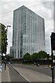
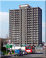
2
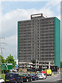
Britannia Point
Refurbished tower at Colliers Wood.
Image: © David Bremner
Taken: 30 Sep 2023
0.01 miles
3
The Colliers Wood Tower
According to a Wikipedia entry http://en.wikipedia.org/wiki/Colliers_Wood this has been named the ugliest building in London. Others may see it more charitably as a typical example of functional 1960s design. Either way, cheap office space was being advertised prominently (other online sources suggest it had been completely unoccupied for some time).
Image: © Stephen Craven
Taken: 13 Jan 2010
0.01 miles
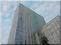
4
Britannia Point, Christchurch Road, SW19
Built in 1966 and known variously over the years as Lyon Tower, The Vortex, Brown & Root Tower, this multi-storey block was voted in 2006 as one of the ugliest buildings in the country. But with its refurbishment only recently completed, it has lost much of its former Brutalist grimness.
Image: © David Kemp
Taken: 25 Oct 2017
0.01 miles
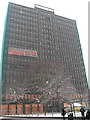
7
Lyon Tower, High Street Colliers Wood
Built in 1966 to the designs of Bader and Miller for property developers, Ronald Lyon Holdings. It has lain empty for some years, partly boarded up and clad in green netting to stop injury from falling debris, and all schemes for redevelopment have foundered.
"Quite well-proportioned, with strongly projecting mullions, but all in a grim dark grey", wrote Pevsner, in his characteristically accurate and pithy way.
It has been voted one of London's ugliest buildings and a blight on the area which I find very odd as there are far uglier shopping centres a stone's throw away, and even if this building is not beautiful it adds interest to an otherwise nondescript area. It must be said that it is somewhat out of scale with surrounding buildings, as if a plan to emulate central Croydon a few miles north had ground to a halt with only one building having been completed.
The circular car park was in the process of being demolished - see here for a close-up: Image
Image: © Stephen Richards
Taken: Unknown
0.02 miles
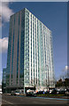
8
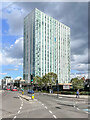
Britannia Point
Originally built in 1966 as an office block named Lyon House, but more generally known as Colliers Wood Tower. It was considered one of the ugliest buildings in London. A major renovation was carried out 2014-7 which saw its conversion to residential apartments.
Image: © Ian Capper
Taken: 7 Oct 2022
0.02 miles
9
Lyon Tower denuded
Her diaphanous clothing (Image]) has finally been removed as part of a revamp. This long-defunct 1960s office block is to be converted to flats and shops. Poor old dear.
Image: © Stephen Richards
Taken: 6 Apr 2015
0.02 miles
10
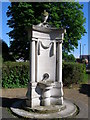
The Feeny Monument; Colliers Wood
The memorial fountain inside Wandle Park, Colliers Wood.
Image: © I M Chengappa
Taken: 26 Apr 2009
0.02 miles