IMAGES TAKEN NEAR TO
Boundary Road, LONDON, SW19 2AX
Introduction
This page details the photographs taken nearby to Boundary Road, SW19 2AX by members of the Geograph project.
The Geograph project started in 2005 with the aim of publishing, organising and preserving representative images for every square kilometre of Great Britain, Ireland and the Isle of Man.

There are currently over 7.5m images from over14,400 individuals and you can help contribute to the project by visiting https://www.geograph.org.uk
Image Map
Images are licensed for reuse under creativecommons.org/licenses/by-sa/2.0
Notes
- Clicking on the map will re-center to the selected point.
- The higher the marker number, the further away the image location is from the centre of the postcode.
Image Listing (83 Images Found)
Images are licensed for reuse under creativecommons.org/licenses/by-sa/2.0
Image
Details
Distance
1
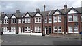
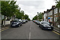
Collier's Wood - Terrace Houses on Carter Road
Image: © James Emmans
Taken: 28 Aug 2016
0.05 miles
2
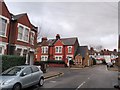
Briscoe Road / Boundary Road junction
Two suburban roads cross in Collier's Wood. Briscoe Road is in the foreground. Ahead, Kimble Road, clearly of later date, is a no through road.
Image: © Derek Harper
Taken: 30 Nov 2009
0.07 miles
3
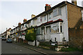
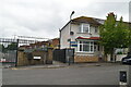
Boundary Road, SW19
House and flat prices in this part of Tooting have increased dramatically in recent years.
Image: © David Kemp
Taken: 1 Nov 2017
0.07 miles
5

Collier's Wood, pumping station
Wandle Valley Pumping Station, on South Road.
Image: © Mike Faherty
Taken: 23 Nov 2013
0.08 miles
7
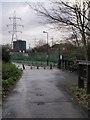
Mead Path
The path, carrying NCN 22, approaches Wandle Valley sewage works and some pylons. The concrete bollards indicate the end of Boundary Road, on the left.
Image: © Derek Harper
Taken: 30 Nov 2009
0.09 miles
8

Collier's Wood, nature park
Wandle Meadow Nature Park, an urban nature reserve, with grassland, woodland, river and wetland: http://www.merton.gov.uk/environment/openspaces/naturereserves.htm#wandlemeadow
Image: © Mike Faherty
Taken: 23 Nov 2013
0.10 miles
10
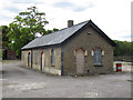
Disused building, Merton STW
A building in the disused Thames Water sewage treatment works in Merton. The high standard of brickwork detailing is typical of 19th / early 20th century municipal engineering.
This site was up for sale with development potential as of 2011, and none of the buildings is listed, so it will probably be demolished before long.
Image: © Stephen Craven
Taken: 29 Aug 2011
0.10 miles