IMAGES TAKEN NEAR TO
Cairns Place, LONDON, SW16 5FS
Introduction
This page details the photographs taken nearby to Cairns Place, SW16 5FS by members of the Geograph project.
The Geograph project started in 2005 with the aim of publishing, organising and preserving representative images for every square kilometre of Great Britain, Ireland and the Isle of Man.

There are currently over 7.5m images from over14,400 individuals and you can help contribute to the project by visiting https://www.geograph.org.uk
Image Map
Images are licensed for reuse under creativecommons.org/licenses/by-sa/2.0
Notes
- Clicking on the map will re-center to the selected point.
- The higher the marker number, the further away the image location is from the centre of the postcode.
Image Listing (62 Images Found)
Images are licensed for reuse under creativecommons.org/licenses/by-sa/2.0
Image
Details
Distance
1
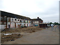
Rowan Park: Remains of Rowan High School
This large school is being demolished, and housing is being built on its site.
Image: © Dr Neil Clifton
Taken: 21 May 2012
0.04 miles
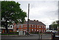
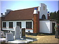
2
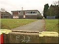
Former Rowan High School, Mitcham
One of the disused school buildings; the site is to be redeveloped as housing, with a community facility, a medical centre, and a landscaped park http://www.merton.gov.uk/rowan_park .
Image: © Derek Harper
Taken: 13 Jan 2011
0.04 miles
3
Rowan High School
Girls secondary school in Streatham; the site is to be developed for housing (2011).
Image: © Colin Smith
Taken: Unknown
0.04 miles
5
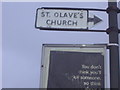
Old sign to St Olave's church, Rowan Road
This is the other side of the same sign.
Image: © David Howard
Taken: 23 Feb 2009
0.06 miles
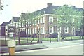
6
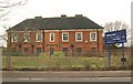
Former Rowan High School, Mitcham
The main school building (see also Image) will be converted into 27 flats according to current redevelopment plans http://www.merton.gov.uk/rowan_park .
Image: © Derek Harper
Taken: 13 Jan 2011
0.06 miles
7
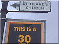
Old sign to St Olave's church, Rowan Road
Although made in the usual pre-Worboys style, when aiming for local buildings these were probably made by the council when using the plain white arrows.
Image: © David Howard
Taken: 23 Feb 2009
0.07 miles
9
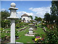
Luff Garden, Streatham Park Cemetery
Streatham Park Cemetery opened as the Great Southern Cemetery in 1909. Up to the Second World War, Streatham Park Cemetery accounted for one fifth of all burials in South London. It is a strange mixture with colourful gardens of remembrance near the entrance in Rowan Road, large mausolea just inside the entrance and a 'street' of even larger mausolea, many to Italians, beyond the war memorial. When I was there, gardeners were busy in the gardens of remembrance and these look neat and tidy. However Darren Beach in 'London's Cemeteries' describes them thus: " The memorial gardens look pretty, but resemble a cross between the Blue Peter Garden and a suburban attempt at a TV-style garden makeover." Much of the rest of the cemetery is quite wild. This is one of the gardens of remembrance, called the Luff Garden.
A more complete history is given at http://www.londongardensonline.org.uk/gardens-online-record.asp?ID=MER056
Image: © Marathon
Taken: 6 Jun 2012
0.10 miles