IMAGES TAKEN NEAR TO
Pollards Hill North, LONDON, SW16 4NZ
Introduction
This page details the photographs taken nearby to Pollards Hill North, SW16 4NZ by members of the Geograph project.
The Geograph project started in 2005 with the aim of publishing, organising and preserving representative images for every square kilometre of Great Britain, Ireland and the Isle of Man.

There are currently over 7.5m images from over14,400 individuals and you can help contribute to the project by visiting https://www.geograph.org.uk
Image Map
Images are licensed for reuse under creativecommons.org/licenses/by-sa/2.0
Notes
- Clicking on the map will re-center to the selected point.
- The higher the marker number, the further away the image location is from the centre of the postcode.
Image Listing (106 Images Found)
Images are licensed for reuse under creativecommons.org/licenses/by-sa/2.0
Image
Details
Distance
1
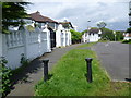
Houses in Pollards Hill North
Pollards Hill occupies the highest point in Norbury and on a clear day the view stretches to Windsor Castle. It was originally part of the Great North Wood and the name 'Pollard' derives from this connection. The road layout of Pollards Hill was shown on maps of 1868 with two avenues of trees. Pollards Hill had been left as an open space as the surrounding estate developed and it was given to Croydon Council in 1913 by Sir Frederick Ederidge. This is Pollards Hill North and this appeared on the 1868 map. The attractive houses right near the summit of the hill are rather more recent. The open space is off to the right. Unusually, there are no parked cars to spoil the photograph.
Image: © Marathon
Taken: 6 Jun 2012
0.01 miles
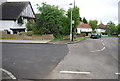
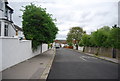
2
Pollards Hill North, Norbury
Pollards Hill North is a residential road in Norbury, in the suburbs of south London.
This image was taken on a February afternoon. Trees were bare for the winter period.
On the horizon is a television transmission mast.
Image: © Malc McDonald
Taken: 19 Feb 2023
0.02 miles
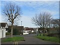
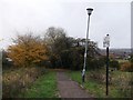
4
Viewpoint at Pollards Hill, Norbury
A path leading to a view point at Pollards Hill, in the suburbs of south London. The pillar to the left of the image is a trigonometry point.
Image: © Malc McDonald
Taken: 19 Feb 2023
0.03 miles
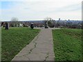
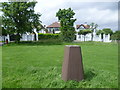
5
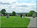
Pollard's Hill Trig Point looking towards Croydon
Image: © tristan forward
Taken: 18 Mar 2010
0.03 miles
6
Houses in Pollards Hill North from Pollards Hill
Pollards Hill occupies the highest point in Norbury and on a clear day the view stretches to Windsor Castle. It was originally part of the Great North Wood and the name 'Pollard' derives from this connection. The road layout of Pollards Hill was shown on maps of 1868 with two avenues of trees. Pollards Hill had been left as an open space as the surrounding estate developed and it was given to Croydon Council in 1913 by Sir Frederick Ederidge. This is looking from the trig point on the summit of Pollards Hill to the houses in Pollards Hill North. This road appeared on the 1868 map, but the attractive houses are rather more recent. Unusually, there are no parked cars to spoil the photograph.
Image: © Marathon
Taken: 6 Jun 2012
0.03 miles
8
Path down Pollards Hill
A path leads from Pollards Hill (road) towards Recreation Way.
Some people prefer to use the grass open-space area on the right to head down.
Nicer views.
Image: © David Anstiss
Taken: 30 Oct 2011
0.03 miles
9
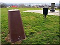
On top of Pollards Hill
Trig point, litter bin and a viewpoint table which lacks the former directions plate on top.
Image: © Robin Webster
Taken: 1 Jul 2011
0.03 miles
10
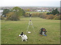
Geography items on Pollards Hill
Required items (for me) to take Image
Camera, foldable tripod, backpack (with food, drink, batteries etc.), Map (at base of tripod) and dog (for company! ).
Taken from spare camera! In case first breaks down.
Image: © David Anstiss
Taken: 30 Oct 2011
0.04 miles