IMAGES TAKEN NEAR TO
Knollys Road, LONDON, SW16 2JX
Introduction
This page details the photographs taken nearby to Knollys Road, SW16 2JX by members of the Geograph project.
The Geograph project started in 2005 with the aim of publishing, organising and preserving representative images for every square kilometre of Great Britain, Ireland and the Isle of Man.

There are currently over 7.5m images from over14,400 individuals and you can help contribute to the project by visiting https://www.geograph.org.uk
Image Map
Images are licensed for reuse under creativecommons.org/licenses/by-sa/2.0
Notes
- Clicking on the map will re-center to the selected point.
- The higher the marker number, the further away the image location is from the centre of the postcode.
Image Listing (25 Images Found)
Images are licensed for reuse under creativecommons.org/licenses/by-sa/2.0
Image
Details
Distance
2
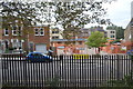
Hitherfield Primary School and Hitherfield Road Baptist Church
Hitherfield Primary School extends from Hitherfield Road as far as the railway line between Streatham Hill and West Norwood. Hitherfield Road Baptist Church was opened in 1907 on the site of a previously demolished house. See also https://www.geograph.org.uk/photo/2064883
Image: © Marathon
Taken: 1 Sep 2010
0.11 miles
3
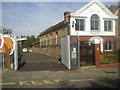
Hitherfield Road Baptist Church and entrance to Hitherfield Primary School
A house on the site of Hitherfield Road Baptist Church was purchased in 1902 and demolished in 1906. The foundation stone laying ceremony of the church was held on 7th December 1906, and the opening ceremony on 25th April, 1907. To the left of the church is the entrance to Hitherfield Primary School.
Image: © Marathon
Taken: 1 Sep 2010
0.11 miles
5
Hitherfield Road, Streatham
Hitherfield Road is quite steep. At the foot of the hill is Leigham Vale and the railway between Streatham and Tulse Hill. Beyond, the other side of the valley slopes up again. The valley is followed by an underground stream which is a tributary of the River Effra.
Image: © Marathon
Taken: 1 Sep 2010
0.14 miles
6
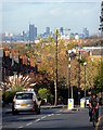
View down Knight's Hill (2)
A number of prominent buildings in central London are visible.
The tower under construction (above the car) is Strata, a block of flats at Elephant Castle (2007-10, by Hamilton's Architects).
Immediately to its left can be seen the dome of St Paul's Cathedral.
To its right can be seen the three Barbican towers - Cromwell, Shakespeare, and Lauderdale (1965-76, Chamberlin, Powell and Bon).
Pity the poor cyclist. He didn't even notice me standing in his way.
Image: © Stephen Richards
Taken: Unknown
0.16 miles
8

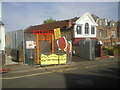
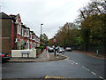
A place to buy a shed
By a mini-roundabout on the junction of Leigham Vale and Knollys Road.
Image: © Bill Boaden
Taken: 2 Aug 2014
0.17 miles
9
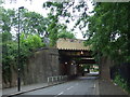
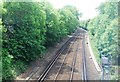
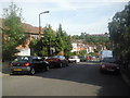
Leigham Vale railway bridges, near Tulse Hill
Two railway bridges crossing Leigham Vale in South London. The space beneath the bridges is quite narrow, therefore the pavement is only on one side of the road here.
Image: © Malc McDonald
Taken: 30 May 2011
0.18 miles