IMAGES TAKEN NEAR TO
Keswick Road, LONDON, SW15 2RA
Introduction
This page details the photographs taken nearby to Keswick Road, SW15 2RA by members of the Geograph project.
The Geograph project started in 2005 with the aim of publishing, organising and preserving representative images for every square kilometre of Great Britain, Ireland and the Isle of Man.

There are currently over 7.5m images from over14,400 individuals and you can help contribute to the project by visiting https://www.geograph.org.uk
Image Map
Images are licensed for reuse under creativecommons.org/licenses/by-sa/2.0
Notes
- Clicking on the map will re-center to the selected point.
- The higher the marker number, the further away the image location is from the centre of the postcode.
Image Listing (95 Images Found)
Images are licensed for reuse under creativecommons.org/licenses/by-sa/2.0
Image
Details
Distance
1
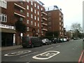
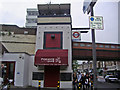
Millbrooke Court, Keswick Road, East Putney
The view of the apartments in Keswick Road which are known as Millbrooke Court. Soul Brothers Records are next door to the apartments.
Image: © Sandy Gemmill
Taken: 4 Feb 2023
0.01 miles
2
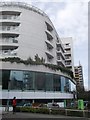
SWG House, Wandsworth
Large modern building on the junction of Keswick Road (in front) and Upper Richmond Road. The lower floor is used by a Co-Operative supermarket.
Image: © David Anstiss
Taken: 14 Apr 2013
0.02 miles
3
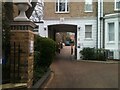
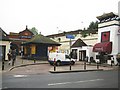
Cavalry Gardens
The view of Cavalry Gardens, a no through road, in Putney
Image: © Sandy Gemmill
Taken: 4 Feb 2023
0.04 miles
4
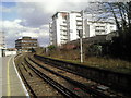
Disused platform at East Putney
The station was opened by the Metropolitan District Railway in 1889 on an extension from Putney Bridge station to Wimbledon. The District Line tracks are out of the picture to the left. The tracks here are used by empty stock trains or occasional diversions by Southwest Trains when the line between Wimbledon and Clapham Junction needs to be avoided. The disused platform on the right hand side of the photograph was last used by stopping passenger trains in 1941.
Image: © Marathon
Taken: 16 Feb 2011
0.05 miles
6
East Putney Underground station
The station dates from 1889 and was originally built by the Metropolitan Railway. It is in the centre of a Y-shaped arrangement of elevated railways. The railway on the east side of the Y is now disused, and District Line trains use the elevated route in the photograph which forms the western arm of the Y. The words 'East Putney' can just be picked out in relief at the top of the white buttress on the right. The van belongs to Tube Lines, yet another body with responsibility for running some part of the railway infrastructure, in this case providing maintenance services for trains and infrastructure on the Jubilee, Northern and Piccadilly lines...
Image: © Nigel Cox
Taken: 28 May 2008
0.06 miles
7
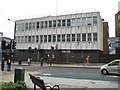
Putney: Wandsworth County Court
The Court is located on the north side of the Upper Richmond Road (the A205 South Circular Road), just to the east (as evidenced by the sign!) of East Putney tube station.
Image: © Nigel Cox
Taken: 28 May 2008
0.06 miles
8
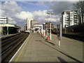
East Putney station
The station was opened by the Metropolitan District Railway in 1889 on an extension from Putney Bridge station to Wimbledon. District Line trains now run along the two left hand tracks. The right hand tracks are used by empty stock trains or occasional diversions by Southwest Trains when the line between Wimbledon and Clapham Junction needs to be avoided. The disused platform on the right hand side of the photograph was last used by stopping passenger trains in 1941.
Image: © Marathon
Taken: 16 Feb 2011
0.06 miles
9
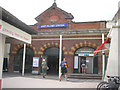
East Putney Station
Showing the external aspect of the station from the South Circular Road
Image: © Dr Neil Clifton
Taken: 25 Jun 2013
0.06 miles
10
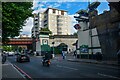
Putney : Upper Richmond Road A205
Looking along the A205.
Image: © Lewis Clarke
Taken: 27 Jun 2022
0.06 miles