IMAGES TAKEN NEAR TO
Carlton Drive, LONDON, SW15 2BU
Introduction
This page details the photographs taken nearby to Carlton Drive, SW15 2BU by members of the Geograph project.
The Geograph project started in 2005 with the aim of publishing, organising and preserving representative images for every square kilometre of Great Britain, Ireland and the Isle of Man.

There are currently over 7.5m images from over14,400 individuals and you can help contribute to the project by visiting https://www.geograph.org.uk
Image Map
Images are licensed for reuse under creativecommons.org/licenses/by-sa/2.0
Notes
- Clicking on the map will re-center to the selected point.
- The higher the marker number, the further away the image location is from the centre of the postcode.
Image Listing (111 Images Found)
Images are licensed for reuse under creativecommons.org/licenses/by-sa/2.0
Image
Details
Distance
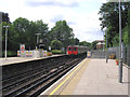
1
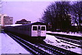
Snow at East Putney
A train on London Underground's District Line leaving East Putney station heading to Wimbledon, in snow.
Image: © Malc McDonald
Taken: 9 Feb 1986
0.06 miles
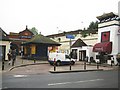
2
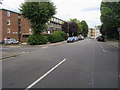
Carlton Drive
Carlton Drive passing Mercier Road
Image: © Shaun Ferguson
Taken: 10 Jul 2009
0.07 miles
3
Disused Network Rail platforms at East Putney
East Putney is the junction of the London Underground District line and the Network Rail (formerly London and South Western Railway) link from the Windsor lines to the South Western main line near Wimbledon. The latter is now single track and is only normally used for empty stock workings to and from East Wimbledon depot, hence the overgrown state of the far platform. For a good many years, the line between here and Wimbledon was owned by British Rail despite the passenger train service being provided almost exclusively by the Underground, hence the Network SouthEast signage and decor in Image By 2007, ownership of the line from here to a point just south of Wimbledon Park station had passed to the Underground, although in 2014 it was still signalled by Network Rail equipment controlled from Wimbledon.
Image: © Richard Vince
Taken: 16 May 2014
0.07 miles
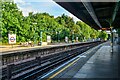
4
East Putney station, 1991
View northward, LT District Line leftwards towards Central London and Upminster, also High Street Kensington and Edgware Road. Rightwards are the ex-LSWR lines to Clapham Junction and Waterloo: the platforms on that line were closed from 5/5/41 when the regular local services by that route ceased, but diverted through trains and especially empty stock used the loop, joining the Windsor Lines at Point Pleasant Junction; the Up line of this loop had just been closed (2/91) and the Down line resignalled for reversible working.
Image: © Ben Brooksbank
Taken: 15 Aug 1991
0.08 miles
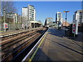
5
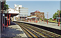
East Putney Station
Looking south. A train of D78 District Line stock has just left, bound for Wimbledon.
Image: © Dr Neil Clifton
Taken: 25 Jun 2013
0.08 miles
6
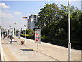
East Putney Underground station, London
Opened in 1889 jointly by the Metropolitan District Railway on the line from Wimbledon to Earls Court, and the London & South Western Railway.
View north towards Putney Bridge and Earls Court, which is now the District Line. Like 55% of the London Underground network, this part is actually overground.
The platforms to the far right were used by LSWR trains from Wimbledon to Clapham Junction via Wandsworth Town, but have not been in regular service since April 1941. The line is however used regularly by through 'mainline' trains.
Image: © Nigel Thompson
Taken: 30 Jan 2019
0.08 miles
7
Putney : East Putney
It is on the Wimbledon branch of the District Line, between Putney Bridge and Southfields, and is on the boundary between Travelcard Zones 2 and 3. The entrance to the station is on Upper Richmond Road.
Image: © Lewis Clarke
Taken: 27 Jun 2022
0.08 miles
8
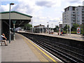
East Putney Station
This station is served by trains of London Transport's District Line, between Edgware Road and Wimbledon, or between Wimbledon and Mansion House and points east thereof. The line on the extreme right is a seldom-used National Rail spur which links to Clapham Junction.
Image: © Dr Neil Clifton
Taken: 25 Jun 2013
0.08 miles
9
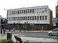
Putney: Wandsworth County Court
The Court is located on the north side of the Upper Richmond Road (the A205 South Circular Road), just to the east (as evidenced by the sign!) of East Putney tube station.
Image: © Nigel Cox
Taken: 28 May 2008
0.09 miles
10
East Putney Underground station
The station dates from 1889 and was originally built by the Metropolitan Railway. It is in the centre of a Y-shaped arrangement of elevated railways. The railway on the east side of the Y is now disused, and District Line trains use the elevated route in the photograph which forms the western arm of the Y. The words 'East Putney' can just be picked out in relief at the top of the white buttress on the right. The van belongs to Tube Lines, yet another body with responsibility for running some part of the railway infrastructure, in this case providing maintenance services for trains and infrastructure on the Jubilee, Northern and Piccadilly lines...
Image: © Nigel Cox
Taken: 28 May 2008
0.09 miles