IMAGES TAKEN NEAR TO
The Retreat, LONDON, SW14 8SS
Introduction
This page details the photographs taken nearby to The Retreat, SW14 8SS by members of the Geograph project.
The Geograph project started in 2005 with the aim of publishing, organising and preserving representative images for every square kilometre of Great Britain, Ireland and the Isle of Man.

There are currently over 7.5m images from over14,400 individuals and you can help contribute to the project by visiting https://www.geograph.org.uk
Image Map (Loading...)


Getting Data...Please wait
Leaflet Map data © OpenStreetMap
Images are licensed for reuse under creativecommons.org/licenses/by-sa/2.0
Notes
- Clicking on the map will re-center to the selected point.
- The higher the marker number, the further away the image location is from the centre of the postcode.
Image Listing (158 Images Found)
Images are licensed for reuse under creativecommons.org/licenses/by-sa/2.0
Image
Details
Distance
1
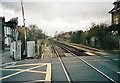
Level crossing on White Hart Lane, Mortlake
Image: © David Howard
Taken: Unknown
0.04 miles
2
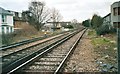
Railway lines from White Hart Lane, Mortlake
Image: © David Howard
Taken: Unknown
0.04 miles
3
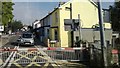
White Hart Lane, Mortlake, from the train
Level crossings are relatively unusual in London, but the line from Clapham Junction to Richmond is characterised by a run of several. Plans to use this line for a fast link to Heathrow foundered repeatedly on this fact: increased use of the line would mean these gates were closed every few minutes, immobilising traffic, whilst replacing them with bridges in this low-lying terrain would mean many residents' view out of the front door would be of the side of a ramp carrying the road over the railway.
Image: © Christopher Hilton
Taken: 8 Aug 2013
0.05 miles
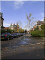
4
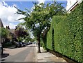
Fitzgerald Avenue, Mortlake
The privet hedge - with its arch over a gateway - is a feature which would have attracted little notice in these suburban streets half a century ago. Given the present-day emphasis on 'low maintenance' - and with many front gardens converted to parking spaces - it seemed worth recording for Geograph.
Image: © Stefan Czapski
Taken: 9 May 2014
0.06 miles
6
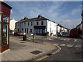
White Hart Lane and Westfields Avenue
A road junction in Mortlake; White Hart Lane is the main road. Westfields Avenue, which runs parallel to Image, recalls one of the neighbourhood's names: Westfield was a rich market garden on this site. The pleasant, modest terraces now give rise to the name "Little Chelsea".
Image: © Derek Harper
Taken: 15 Apr 2010
0.07 miles
7
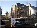
House in Fitzgerald Avenue, Mortlake
No. 1A Fitzgerald Avenue has an entry in the book Nairn's London by Ian Nairn where it is described as "a wonderful toy fort made up of genuine bits and genuine fantasy". He mentions the huge Wren-style door dated 1696, as well as the columns and battlements. It certainly seems to sit rather oddly here in suburbia.
Image: © Marathon
Taken: 10 Nov 2010
0.08 miles
8
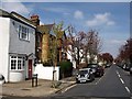
First Avenue, Mortlake
The first of a series of streets parallel to and west of Image After this and Second Avenue, the names become more imaginative. Viewed from North Worple Way, which runs across the southern end of each of the streets.
Image: © Derek Harper
Taken: 15 Apr 2010
0.09 miles
9
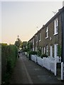
Railway Side, Barnes
No longer quite as close to the railway as the name might suggest. These days a roughly triangular plot of land (used as allotments) lies between Railway Side and the Waterloo-Windsor line.
However, a railway line once passed much closer. West of Barnes station the line out of Waterloo forks - one branch running west to Windsor, the other north-west towards Hounslow (the Hounslow Loop). The Barnes Curve - which once ran parallel to Railway Side - completed a triangular layout, leaving the Windsor line near White Hart Lane, and joining the Hounslow line close to Barnes Bridge.
All the lines involved were built by the London & South Western Railway. The Barnes Curve opened to traffic in 1862, but was lifted as early as 1881. I can find no reference to it in Dendy Marshall's 'History of the Southern Railway' - and my prime source of information is Ian Yarham's Geograph: http://www.geograph.org.uk/photo/2237211
Image: © Stefan Czapski
Taken: 17 May 2014
0.09 miles
10
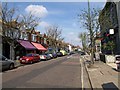
White Hart Lane, Mortlake
Some colourful shop canopies opposite the junction with Image, with gables above the facades.
Image: © Derek Harper
Taken: 15 Apr 2010
0.10 miles