IMAGES TAKEN NEAR TO
Paynesfield Avenue, LONDON, SW14 8DW
Introduction
This page details the photographs taken nearby to Paynesfield Avenue, SW14 8DW by members of the Geograph project.
The Geograph project started in 2005 with the aim of publishing, organising and preserving representative images for every square kilometre of Great Britain, Ireland and the Isle of Man.

There are currently over 7.5m images from over14,400 individuals and you can help contribute to the project by visiting https://www.geograph.org.uk
Image Map (Loading...)


Getting Data...Please wait
Leaflet Map data © OpenStreetMap
Images are licensed for reuse under creativecommons.org/licenses/by-sa/2.0
Notes
- Clicking on the map will re-center to the selected point.
- The higher the marker number, the further away the image location is from the centre of the postcode.
Image Listing (160 Images Found)
Images are licensed for reuse under creativecommons.org/licenses/by-sa/2.0
Image
Details
Distance
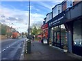
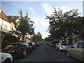
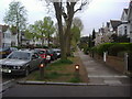
2
Pavement on East Sheen Avenue
From Upper Richmond Road
Image: © David Howard
Taken: 18 Oct 2014
0.08 miles
3
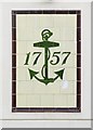
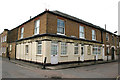
Tiled panel (1), former "Queen's Arms", Mortlake
The old 'Queen's Arms' - now a private dwelling - stands at the corner of Queen's Road and Prince's Road, Mortlake. Much of the external tiling of the old Charrington's pub has been retained - in a neighbourhood of former artisans' cottages. The date 1757 commemorates the founding of the Anchor Brewery in the Mile End Road - a business which John Charrington bought into a few years later http://en.wikipedia.org/wiki/Charrington_Brewery
The anchor panel faces Prince's Road. The pub's name survives on a tiled panel round the corner in Queen's Road http://www.geograph.org.uk/photo/2964839
Image: © Stefan Czapski
Taken: 19 May 2012
0.08 miles
4
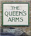
Tiled panel (2), the former "Queen's Arms", Mortlake
The old 'Queen's Arms' - now a private dwelling - stands at the corner of Queen's Road and Prince's Road, Mortlake. Much of the external tiling of the old Charrington's pub has been retained - in a neighbourhood of former artisans' cottages. The pub name appears in this panel on an east-facing wall in Queen's Road.
Another panel, just round the corner in Prince's Road, is shown here: http://www.geograph.org.uk/photo/2964831
Image: © Stefan Czapski
Taken: 19 May 2012
0.08 miles
5
Mortlake: Former 'Queen's Arms'
Not a pub now and it has probably been converted to houses for some time, but the original signage has, sensibly, been kept and is well maintained. Charrington's Brewery in the City was taken over by Whitbread in the early fifties, but they maintained the 'Charrington's IPA' name for some years.
Image: © Dr Neil Clifton
Taken: 24 Apr 2013
0.09 miles
6
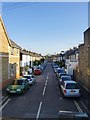
Queen's Road, Mortlake
Looking south from the footbridge across the railway: http://www.geograph.org.uk/photo/2652146
Image: © Stefan Czapski
Taken: 13 Apr 2014
0.09 miles
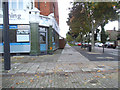
7
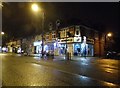
Shops on Upper Richmond Road, East Sheen
Image: © David Howard
Taken: 14 Oct 2014
0.10 miles
10
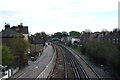
Mortlake: View east from footbridge
Looking in the Up direction, the other footbridge can be seen; behind it and on the right is the Mortlake Old Burial Ground.
Image: © Dr Neil Clifton
Taken: 24 Apr 2013
0.12 miles