IMAGES TAKEN NEAR TO
Lowther Mansions, Church Road, LONDON, SW13 9HT
Introduction
This page details the photographs taken nearby to Lowther Mansions, Church Road, SW13 9HT by members of the Geograph project.
The Geograph project started in 2005 with the aim of publishing, organising and preserving representative images for every square kilometre of Great Britain, Ireland and the Isle of Man.

There are currently over 7.5m images from over14,400 individuals and you can help contribute to the project by visiting https://www.geograph.org.uk
Image Map
Images are licensed for reuse under creativecommons.org/licenses/by-sa/2.0
Notes
- Clicking on the map will re-center to the selected point.
- The higher the marker number, the further away the image location is from the centre of the postcode.
Image Listing (266 Images Found)
Images are licensed for reuse under creativecommons.org/licenses/by-sa/2.0
Image
Details
Distance
1
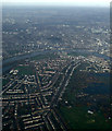
Barnes from the air
The London Wetland Centre is on the right.
Image: © Thomas Nugent
Taken: 24 Nov 2014
0.01 miles
3
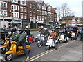
Scooters, Barnes
This group of scooters is part of a scooter club heading along Castlenau (road) towards Putney.
Image: © David Anstiss
Taken: 14 Apr 2013
0.03 miles
4
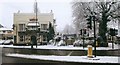
Red Lion, Barnes, under snow
The Red Lion, corner of Castelnau and Queen Elizabeth Walk, taken Winter 2002/3.
It has since been renovated and turned into a "gastro-pub".
Image: © Baggy Suggs
Taken: 8 Jan 2003
0.03 miles
5
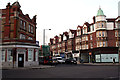
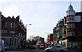
Barnes: an important road junction
Looking west across the A306, we see Church Road (A3003) straight ahead, which leads to Barnes 'village centre', if that's what you would call it, around the pond. To the left is the unclassified Elm Grove Road, but sharp left is the A306 Rocks Lane, leading to Roehampton and the South Circular. Sharp right the A306 continues as Castelnau (former name: Upper Bridge Road) to Hammersmith Bridge.
Image: © Dr Neil Clifton
Taken: 8 Jan 2013
0.03 miles
6
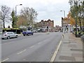
Red Lion crossroads, Barnes
Looking from Castlenau (A306) towards the Red Lion crossroads. From left to right the streets are Queen Elizabeth Walk (hidden), Rocks Lane (A306), Elm Grove Road, Church Road (A3003) which continues on to Barnes High Street.
Image: © Oliver Dixon
Taken: 23 Nov 2016
0.03 miles
7
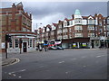
Junction of Rocks Lane, Church Rd, Elm Grove Rd & Castelnau, Barnes
Image: © John Lord
Taken: 7 Sep 2010
0.03 miles
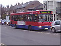
8
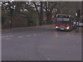
72 bus at the lights, Rocks Lane, Barnes
Image: © David Howard
Taken: 16 Nov 2008
0.04 miles
10
Thank you to local bus drivers
This was a bus shelter at the Red Lion Barnes to thank local bus drivers for working during the COVID-19 lockdown.
Image: © Marathon
Taken: 15 Jul 2020
0.04 miles