IMAGES TAKEN NEAR TO
Rectory Road, LONDON, SW13 0DU
Introduction
This page details the photographs taken nearby to Rectory Road, SW13 0DU by members of the Geograph project.
The Geograph project started in 2005 with the aim of publishing, organising and preserving representative images for every square kilometre of Great Britain, Ireland and the Isle of Man.

There are currently over 7.5m images from over14,400 individuals and you can help contribute to the project by visiting https://www.geograph.org.uk
Image Map (Loading...)


Getting Data...Please wait
Leaflet Map data © OpenStreetMap
Images are licensed for reuse under creativecommons.org/licenses/by-sa/2.0
Notes
- Clicking on the map will re-center to the selected point.
- The higher the marker number, the further away the image location is from the centre of the postcode.
Image Listing (106 Images Found)
Images are licensed for reuse under creativecommons.org/licenses/by-sa/2.0
Image
Details
Distance
1
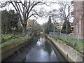
Beverley Brook, Barnes
As seen from Rocks Lane.
Looking upstream.
This stream rises at Cuddington Recreation Park in Worcester Park, before flowing through Motspur Park, New Malden, Wimbledon Common, Richmond Park, and then Putney to head towards the River Thames.
Image: © David Anstiss
Taken: 14 Apr 2013
0.09 miles
2
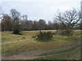
Barnes Common
Barnes Common between Mill Hill Road and Ranelagh Avenue
Image: © Shaun Ferguson
Taken: 18 Dec 2008
0.09 miles
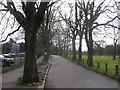
3
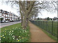
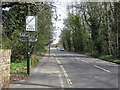
Path beside Rocks Lane
Rocks Lane leads Upper Richmond Road towards Barnes.
This path leads beside Barnes Elms Playing Fields (on the right).
Image: © David Anstiss
Taken: 14 Apr 2013
0.12 miles
4
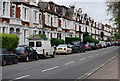
Barnes: Ranelagh Avenue
Looking west from its junction with Rocks Lane. These substantial houses, once family homes, are now subdivided into flats.
Image: © Dr Neil Clifton
Taken: 8 Jan 2013
0.12 miles
5
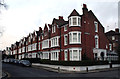
Housing on Rocks Road, Barnes
Typical early 20th century housing in a SW London suburb.
Image: © N Chadwick
Taken: 4 May 2008
0.13 miles
7
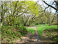
On Barnes Common
There is a network of surfaced and unsurfaced paths.
Image: © Robin Webster
Taken: 14 Apr 2012
0.14 miles
8
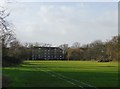
Playing fields at Barn Elms
Looking west towards Rocks Lane. The strip of woodland on the right marks the course of Beverley Brook.
Image: © Stefan Czapski
Taken: 31 Jan 2013
0.15 miles
9
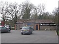
Changing Rooms, Barnes
Beside Rocks Lane.
Near Beverley Brook Recreational Ground and a group of enclosed artificial grassed pitches.
Image: © David Anstiss
Taken: 14 Apr 2013
0.15 miles
10
Path to Lower Richmond Road, Barnes
A path leads from Rock Lane, past Rock Lane Multi Sport Centre (on the left) towards Putney Lower Common.
Image: © David Anstiss
Taken: 14 Apr 2013
0.16 miles