IMAGES TAKEN NEAR TO
Westfields Avenue, LONDON, SW13 0AU
Introduction
This page details the photographs taken nearby to Westfields Avenue, SW13 0AU by members of the Geograph project.
The Geograph project started in 2005 with the aim of publishing, organising and preserving representative images for every square kilometre of Great Britain, Ireland and the Isle of Man.

There are currently over 7.5m images from over14,400 individuals and you can help contribute to the project by visiting https://www.geograph.org.uk
Image Map (Loading...)


Getting Data...Please wait
Leaflet Map data © OpenStreetMap
Images are licensed for reuse under creativecommons.org/licenses/by-sa/2.0
Notes
- Clicking on the map will re-center to the selected point.
- The higher the marker number, the further away the image location is from the centre of the postcode.
Image Listing (201 Images Found)
Images are licensed for reuse under creativecommons.org/licenses/by-sa/2.0
Image
Details
Distance
1

Flower crab spider goes yellow
Taking time out from waiting in ambush on our pink roses, this one joins the yellow movement lower down the eastern fence of our garden.
Image: © Richard Warrick
Taken: 5 Aug 2020
0.02 miles
2
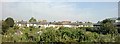
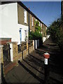
Allotments and cottages beyond, Railway Side, Mortlake
Image: © Christopher Hilton
Taken: 8 Aug 2013
0.03 miles
3
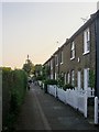
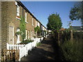
Railway Side, Barnes
No longer quite as close to the railway as the name might suggest. These days a roughly triangular plot of land (used as allotments) lies between Railway Side and the Waterloo-Windsor line.
However, a railway line once passed much closer. West of Barnes station the line out of Waterloo forks - one branch running west to Windsor, the other north-west towards Hounslow (the Hounslow Loop). The Barnes Curve - which once ran parallel to Railway Side - completed a triangular layout, leaving the Windsor line near White Hart Lane, and joining the Hounslow line close to Barnes Bridge.
All the lines involved were built by the London & South Western Railway. The Barnes Curve opened to traffic in 1862, but was lifted as early as 1881. I can find no reference to it in Dendy Marshall's 'History of the Southern Railway' - and my prime source of information is Ian Yarham's Geograph: http://www.geograph.org.uk/photo/2237211
Image: © Stefan Czapski
Taken: 17 May 2014
0.04 miles
5
Archway Street, Mortlake
A resident who wondered what I was doing said he chose to live in this road because of its architectural appearance; an architect explained that the combined height of the houses on either side equalled the total distance between them.
Image: © Derek Harper
Taken: 15 Apr 2010
0.05 miles
6

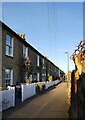
Allotments and apple tree, Railway Side, Barnes
Seen from Railway Side, which for most of its length is no more than a footpath. The buildings in the background stand on the far side of the railway line from Waterloo to Windsor.
As I understand it, the apple tree is growing on what was once the track-bed of the old London & South Western Railway's Barnes Curve (hence the name Railway Side). More history here: http://www.geograph.org.uk/photo/3986505
Image: © Stefan Czapski
Taken: 17 May 2014
0.05 miles
7
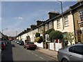
Railway Side, Barnes
This row of cottages known as Railway Side marks the line of the Barnes Curve, a double track railway line built so that trains could go from Mortlake on the Richmond line to Barnes Bridge on the Hounslow Loop and eliminate reversing at Barnes. The Barnes curve opened in 1862 and was removed in 1881.
Image: © Marathon
Taken: 10 Nov 2010
0.07 miles
8
Railway Side, Barnes
This row of cottages known as Railway Side marks the line of the Barnes Curve, a double track railway line built so that trains could go from Mortlake on the Richmond line to Barnes Bridge on the Hounslow Loop and eliminate reversing at Barnes. The Barnes Curve opened in 1862 and was removed in 1881.
Image: © Marathon
Taken: 10 Nov 2010
0.07 miles
9
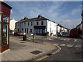
White Hart Lane and Westfields Avenue
A road junction in Mortlake; White Hart Lane is the main road. Westfields Avenue, which runs parallel to Image, recalls one of the neighbourhood's names: Westfield was a rich market garden on this site. The pleasant, modest terraces now give rise to the name "Little Chelsea".
Image: © Derek Harper
Taken: 15 Apr 2010
0.08 miles
10
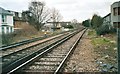
Railway lines from White Hart Lane, Mortlake
Image: © David Howard
Taken: Unknown
0.08 miles